Gangi geodata
Gangi (Sicily) is a seat of a third-order administrative division; located in Italy in Europe/Rome (GMT+2) time zone. With population of 6,430 people, there are 1521 cities with bigger population in this country. Compared to other cities in Italy, 97.8% of cities are located further ↑North; 79.9% of cities are located further ←West and 94.6% of cities have lower elevation than Gangi. Note1


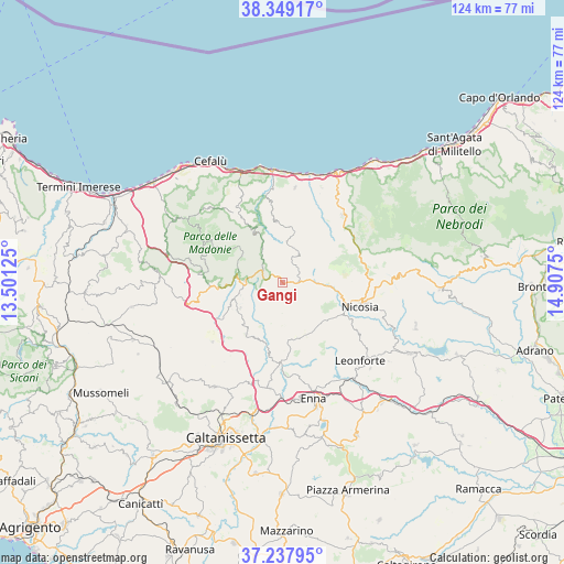
Gangi GPS coordinates[2]
37° 47' 44.34" North, 14° 12' 15.732" East
| Map corner | latitude | longitude |
|---|---|---|
| Upper-left | 38.34917°, | 13.50125° |
| Center: | 37.79565°, | 14.20437° |
| Lower-right: | 37.23795°, | 14.9075° |
| Map W x H: | 123.6×123.6 km | = 76.8×76.8mi |
| max Lat: | 47.04031° ⇑97.8% North |
| Gangi: | 37.79565° |
| min Lat: | ⇓2.2% South 35.50142° |
| min Long | Gangi | max Long |
| 6.69888° | 14.20437° | 18.48682° |
| W 79.9%⇐ | ⇒20.1% E |
Elevation
Elevation of Gangi is 859 m = 2818 ft, and this is 552.3 m = 1812 ft above average elevation for this country.
| Max E: |
2085 m = 6841 ft | 5.4% |
| Gangi | 859 m 2818 ft | |
| Avg. | 306.7 m = 1006 ft | |
Min E: |
-4 m = -13 ft | 94.6% |
See also: Italy elevation on elevation.city.
Geographical zone
Gangi is located in North temperate zone (between Tropic of Cancer and the Arctic Circle). Distance of this Northern Tropic circle is 1596.6 km =992.1 mi to South.| Distance of | km | miles | from Gangi |
|---|---|---|---|
| North Pole | 5804.6 | 3606.8 | to North |
| Arctic Circle | 3198.7 | 1987.6 | to North |
| Tropic Cancer | 1596.6 | 992.1 | to South |
| Equator | 4202.5 | 2611.3 | to South |


Nearby cities:
15 places around Gangi: (largest is in red/bold)
• Alimena
13.9 km =8.6 mi,  214°
214°
• Blufi
12.5 km =7.8 mi,  247°
247°
• Bompietro
11.2 km =7 mi,  239°
239°
• Castel di Lucio
13.8 km =8.6 mi,  42°
42°
• Castelbuono
17.7 km =11 mi,  324°
324°
• Castellana Sicula
14.6 km =9.1 mi,  266°
266°
• Fasanò-Ss.Trinità-Pianello
9.6 km =6 mi,  256°
256°
• Geraci Siculo
8.4 km =5.2 mi,  327°
327°
• Nicosia
17.4 km =10.8 mi,  107°
107°
• Petralia Soprana
8.5 km =5.3 mi, 273°
• Petralia Sottana
9.9 km =6.2 mi,  278°
278°
• Polizzi Generosa
17.8 km =11.1 mi, 275°
• San Mauro Castelverde
13.3 km =8.3 mi,  354°
354°
• Sperlinga
13.3 km =8.3 mi,  104°
104°
• Villadoro
12.5 km =7.8 mi,  156°
156°
Sources, notices
• [Note1] Compared only with cities in Italy existing in our database
• [Src1] Map data: © OpenStreetMap contributors (CC-BY-SA)
• [Src2] Other city data from geonames.org with taken over terms of usage.
• [Src3] Geographical zone / Annual Mean Temperature by Robert A. Rohde @ Wikipedia
