Castelbuono geodata
Castelbuono (Sicily) is a seat of a third-order administrative division; located in Italy in Europe/Rome (GMT+2) time zone. With population of 7,458 people, there are 1304 cities with bigger population in this country. Compared to other cities in Italy, 97.2% of cities are located further ↑North; 78.9% of cities are located further ←West and 76.1% of cities have lower elevation than Castelbuono. Note1


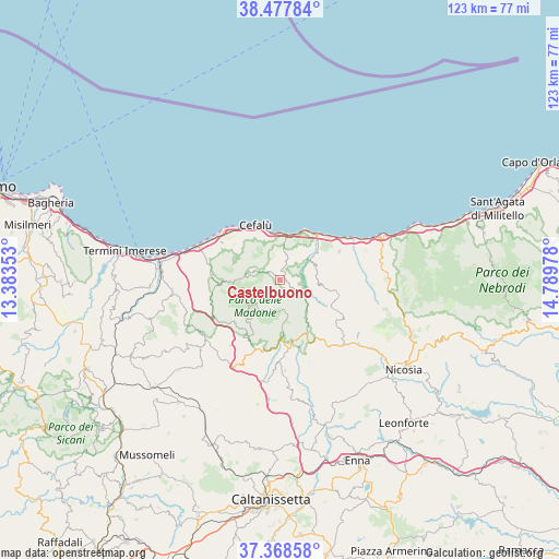
Castelbuono GPS coordinates[2]
37° 55' 31.08" North, 14° 5' 11.94" East
| Map corner | latitude | longitude |
|---|---|---|
| Upper-left | 38.47784°, | 13.38353° |
| Center: | 37.9253°, | 14.08665° |
| Lower-right: | 37.36858°, | 14.78978° |
| Map W x H: | 123.3×123.3 km | = 76.6×76.6mi |
| max Lat: | 47.04031° ⇑97.2% North |
| Castelbuono: | 37.9253° |
| min Lat: | ⇓2.8% South 35.50142° |
| min Long | Castelbuono | max Long |
| 6.69888° | 14.08665° | 18.48682° |
| W 78.9%⇐ | ⇒21.1% E |
Elevation
Elevation of Castelbuono is 467 m = 1532 ft, and this is 160.3 m = 526 ft above average elevation for this country.
| Max E: |
2085 m = 6841 ft | 23.9% |
| Castelbuono | 467 m 1532 ft | |
| Avg. | 306.7 m = 1006 ft | |
Min E: |
-4 m = -13 ft | 76.1% |
See also: Italy elevation on elevation.city.
Geographical zone
Castelbuono is located in North temperate zone (between Tropic of Cancer and the Arctic Circle). Distance of this Northern Tropic circle is 1611 km =1001 mi to South.| Distance of | km | miles | from Castelbuono |
|---|---|---|---|
| North Pole | 5790.2 | 3597.9 | to North |
| Arctic Circle | 3184.3 | 1978.6 | to North |
| Tropic Cancer | 1611 | 1001 | to South |
| Equator | 4216.9 | 2620.3 | to South |


Nearby cities:
15 places around Castelbuono: (largest is in red/bold)
• Castellana Sicula
15.9 km =9.9 mi,  195°
195°
• Cefalù
13.8 km =8.6 mi,  336°
336°
• Collesano
13.1 km =8.1 mi,  266°
266°
• Fasanò-Ss.Trinità-Pianello
16.6 km =10.3 mi,  176°
176°
• Finale
12.3 km =7.6 mi,  32°
32°
• Geraci Siculo
9.4 km =5.8 mi,  141°
141°
• Gratteri
10.9 km =6.8 mi,  294°
294°
• Isnello
7.2 km =4.5 mi, 285°
• Lascari
15.3 km =9.5 mi,  303°
303°
• Petralia Soprana
14 km =8.7 mi,  172°
172°
• Petralia Sottana
12.9 km =8 mi, 177°
• Polizzi Generosa
14.6 km =9.1 mi,  210°
210°
• Pollina
9.2 km =5.7 mi, 34°
• San Mauro Castelverde
9.1 km =5.7 mi,  97°
97°
• Tusa
14.6 km =9.1 mi,  63°
63°
Sources, notices
• [Note1] Compared only with cities in Italy existing in our database
• [Src1] Map data: © OpenStreetMap contributors (CC-BY-SA)
• [Src2] Other city data from geonames.org with taken over terms of usage.
• [Src3] Geographical zone / Annual Mean Temperature by Robert A. Rohde @ Wikipedia
