Gallodoro geodata
Gallodoro (Sicily) is a seat of a third-order administrative division; located in Italy in Europe/Rome (GMT+2) time zone. With population of 378 people, there are 10359 cities with bigger population in this country. Compared to other cities in Italy, 97.3% of cities are located further ↑North; 89.5% of cities are located further ←West and 68.7% of cities have lower elevation than Gallodoro. Note1


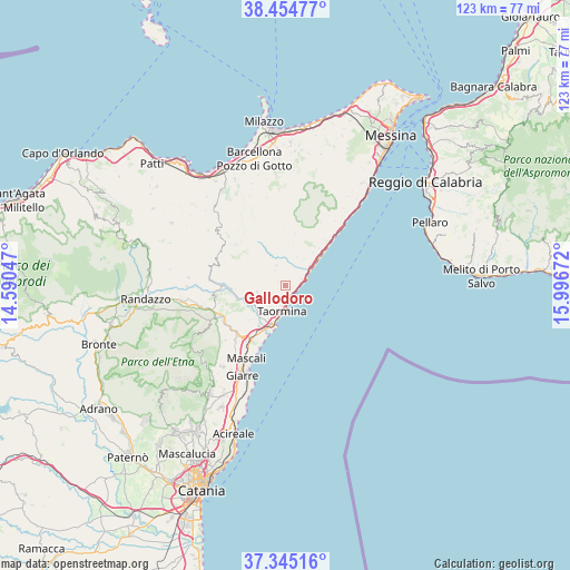
Gallodoro GPS coordinates[2]
37° 54' 7.416" North, 15° 17' 36.924" East
| Map corner | latitude | longitude |
|---|---|---|
| Upper-left | 38.45477°, | 14.59047° |
| Center: | 37.90206°, | 15.29359° |
| Lower-right: | 37.34516°, | 15.99672° |
| Map W x H: | 123.4×123.4 km | = 76.7×76.7mi |
| max Lat: | 47.04031° ⇑97.3% North |
| Gallodoro: | 37.90206° |
| min Lat: | ⇓2.7% South 35.50142° |
| min Long | Gallodoro | max Long |
| 6.69888° | 15.29359° | 18.48682° |
| W 89.5%⇐ | ⇒10.5% E |
Elevation
Elevation of Gallodoro is 381 m = 1250 ft, and this is 74.3 m = 244 ft above average elevation for this country.
| Max E: |
2085 m = 6841 ft | 31.3% |
| Gallodoro | 381 m 1250 ft | |
| Avg. | 306.7 m = 1006 ft | |
Min E: |
-4 m = -13 ft | 68.7% |
See also: Italy elevation on elevation.city.
Geographical zone
Gallodoro is located in North temperate zone (between Tropic of Cancer and the Arctic Circle). Distance of this Northern Tropic circle is 1608.4 km =999.4 mi to South.| Distance of | km | miles | from Gallodoro |
|---|---|---|---|
| North Pole | 5792.7 | 3599.4 | to North |
| Arctic Circle | 3186.9 | 1980.2 | to North |
| Tropic Cancer | 1608.4 | 999.4 | to South |
| Equator | 4214.3 | 2618.6 | to South |


Nearby cities:
15 places around Gallodoro: (largest is in red/bold)
• Casalvecchio Siculo
6.8 km =4.2 mi,  22°
22°
• Castelmola
5.1 km =3.2 mi,  196°
196°
• Forza d'Agrò
3.8 km =2.4 mi,  67°
67°
• Gaggi
7.9 km =4.9 mi,  233°
233°
• Graniti
6.2 km =3.9 mi,  257°
257°
• Letojanni
2.7 km =1.7 mi,  153°
153°
• Limina
4.7 km =2.9 mi,  335°
335°
• Mazzeo
3.4 km =2.1 mi,  169°
169°
• Melia
1.6 km =1 mi,  276°
276°
• Mongiuffi Melia
1.6 km =1 mi, 275°
• Rina
5.7 km =3.5 mi,  38°
38°
• Roccafiorita
3.9 km =2.4 mi,  324°
324°
• Sant'Alessio Siculo
5.6 km =3.5 mi,  62°
62°
• Savoca
7 km =4.3 mi, 35°
• Taormina
5.4 km =3.4 mi,  184°
184°
Sources, notices
• [Note1] Compared only with cities in Italy existing in our database
• [Src1] Map data: © OpenStreetMap contributors (CC-BY-SA)
• [Src2] Other city data from geonames.org with taken over terms of usage.
• [Src3] Geographical zone / Annual Mean Temperature by Robert A. Rohde @ Wikipedia
