Castelmola geodata
Castelmola (Sicily) is a seat of a third-order administrative division; located in Italy in Europe/Rome (GMT+2) time zone. With population of 475 people, there are 10005 cities with bigger population in this country. Compared to other cities in Italy, 97.5% of cities are located further ↑North; 89.4% of cities are located further ←West and 78.3% of cities have lower elevation than Castelmola. Note1


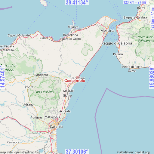
Castelmola GPS coordinates[2]
37° 51' 29.844" North, 15° 16' 37.668" East
| Map corner | latitude | longitude |
|---|---|---|
| Upper-left | 38.41134°, | 14.57401° |
| Center: | 37.85829°, | 15.27713° |
| Lower-right: | 37.30106°, | 15.98026° |
| Map W x H: | 123.5×123.5 km | = 76.7×76.7mi |
| max Lat: | 47.04031° ⇑97.5% North |
| Castelmola: | 37.85829° |
| min Lat: | ⇓2.5% South 35.50142° |
| min Long | Castelmola | max Long |
| 6.69888° | 15.27713° | 18.48682° |
| W 89.4%⇐ | ⇒10.6% E |
Elevation
Elevation of Castelmola is 496 m = 1627 ft, and this is 189.3 m = 621 ft above average elevation for this country.
| Max E: |
2085 m = 6841 ft | 21.7% |
| Castelmola | 496 m 1627 ft | |
| Avg. | 306.7 m = 1006 ft | |
Min E: |
-4 m = -13 ft | 78.3% |
See also: Italy elevation on elevation.city.
Geographical zone
Castelmola is located in North temperate zone (between Tropic of Cancer and the Arctic Circle). Distance of this Northern Tropic circle is 1603.5 km =996.4 mi to South.| Distance of | km | miles | from Castelmola |
|---|---|---|---|
| North Pole | 5797.6 | 3602.5 | to North |
| Arctic Circle | 3191.7 | 1983.2 | to North |
| Tropic Cancer | 1603.5 | 996.4 | to South |
| Equator | 4209.4 | 2615.6 | to South |


Nearby cities:
15 places around Castelmola: (largest is in red/bold)
• Calatabiano
5.9 km =3.7 mi,  224°
224°
• Chianchitta-Pallio
4.6 km =2.9 mi,  206°
206°
• Chianchitta-Trappitello
3.9 km =2.4 mi, 216°
• Forza d'Agrò
8.1 km =5 mi,  38°
38°
• Gaggi
4.9 km =3 mi,  272°
272°
• Gallodoro
5.1 km =3.2 mi,  16°
16°
• Giardini-Naxos
3.5 km =2.2 mi,  194°
194°
• Graniti
5.8 km =3.6 mi,  307°
307°
• Letojanni
3.6 km =2.2 mi,  47°
47°
• Mazzeo
2.6 km =1.6 mi, 53°
• Melia
5.1 km =3.2 mi,  357°
357°
• Mongiuffi Melia
5 km =3.1 mi, 358°
• Pasteria-Lapide
6.9 km =4.3 mi, 218°
• Roccafiorita
8.1 km =5 mi,  353°
353°
• Taormina
1.1 km =0.7 mi,  117°
117°
Sources, notices
• [Note1] Compared only with cities in Italy existing in our database
• [Src1] Map data: © OpenStreetMap contributors (CC-BY-SA)
• [Src2] Other city data from geonames.org with taken over terms of usage.
• [Src3] Geographical zone / Annual Mean Temperature by Robert A. Rohde @ Wikipedia
