Donnalucata geodata
Donnalucata (Sicily) is a populated place; located in Italy in Europe/Rome (GMT+2) time zone. With population of 3,172 people, there are 2913 cities with bigger population in this country. Compared to other cities in Italy, 99.9% of cities are located further ↑North; 84% of cities are located further ←West and 95.9% of cities have higher elevation than Donnalucata. Note1


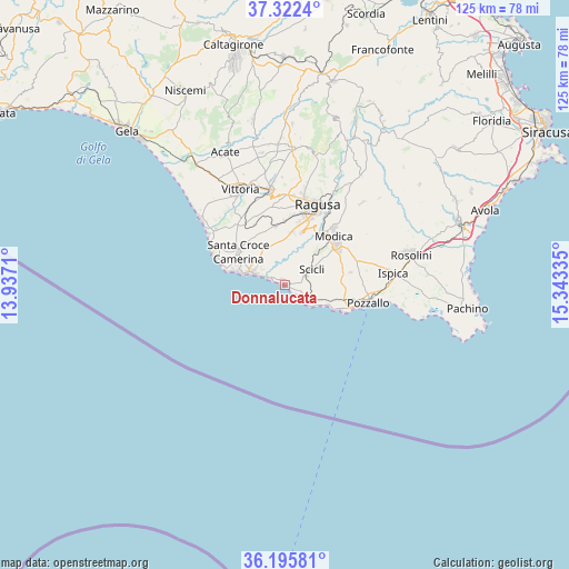
Donnalucata GPS coordinates[2]
36° 45' 40.212" North, 14° 38' 24.792" East
| Map corner | latitude | longitude |
|---|---|---|
| Upper-left | 37.3224°, | 13.9371° |
| Center: | 36.76117°, | 14.64022° |
| Lower-right: | 36.19581°, | 15.34335° |
| Map W x H: | 125.3×125.3 km | = 77.9×77.9mi |
| max Lat: | 47.04031° ⇑99.9% North |
| Donnalucata: | 36.76117° |
| min Lat: | ⇓0.1% South 35.50142° |
| min Long | Donnalucata | max Long |
| 6.69888° | 14.64022° | 18.48682° |
| W 84%⇐ | ⇒16% E |
Elevation
Elevation of Donnalucata is 7 m = 23 ft, and this is 299.7 m = 983 ft below average elevation for this country.
| Max E: |
2085 m = 6841 ft | 95.9% |
| Avg. | 306.7 m = 1006 ft | |
| Donnalucata | 7 m = 23 ft | |
Min E: |
-4 m = -13 ft | 4.1% |
See also: Italy elevation on elevation.city.
Geographical zone
Donnalucata is located in North temperate zone (between Tropic of Cancer and the Arctic Circle). Distance of this Northern Tropic circle is 1481.5 km =920.6 mi to South.| Distance of | km | miles | from Donnalucata |
|---|---|---|---|
| North Pole | 5919.6 | 3678.3 | to North |
| Arctic Circle | 3313.7 | 2059 | to North |
| Tropic Cancer | 1481.5 | 920.6 | to South |
| Equator | 4087.5 | 2539.9 | to South |


Nearby cities:
15 places around Donnalucata: (largest is in red/bold)
• Borgo Europa
24 km =14.9 mi,  320°
320°
• Caucana-Finaiti-Casuzze-Finaiti N.
10.9 km =6.8 mi,  286°
286°
• Cava d'Aliga
5.7 km =3.5 mi,  128°
128°
• Comiso
21.1 km =13.1 mi,  352°
352°
• Ispica
23.8 km =14.8 mi,  83°
83°
• Marina di Modica
13.8 km =8.6 mi,  111°
111°
• Marina di Ragusa
8.1 km =5 mi, 289°
• Modica
15.2 km =9.4 mi,  44°
44°
• Pozzallo
18.7 km =11.6 mi,  100°
100°
• Ragusa
19.8 km =12.3 mi,  22°
22°
• Sampieri
9.7 km =6 mi,  116°
116°
• Santa Croce Camerina
12.7 km =7.9 mi,  306°
306°
• Scicli
6.4 km =4 mi,  59°
59°
• Scoglitti
23.6 km =14.7 mi, 308°
• Vittoria
23.4 km =14.5 mi,  334°
334°
Sources, notices
• [Note1] Compared only with cities in Italy existing in our database
• [Src1] Map data: © OpenStreetMap contributors (CC-BY-SA)
• [Src2] Other city data from geonames.org with taken over terms of usage.
• [Src3] Geographical zone / Annual Mean Temperature by Robert A. Rohde @ Wikipedia
