Ragusa geodata
Ragusa (Sicily) is a seat of a second-order administrative division; located in Italy in Europe/Rome (GMT+2) time zone. With population of 61,380 people, there are 83 cities with bigger population in this country. Compared to other cities in Italy, 99.8% of cities are located further ↑North; 84.7% of cities are located further ←West and 81.1% of cities have lower elevation than Ragusa. Note1


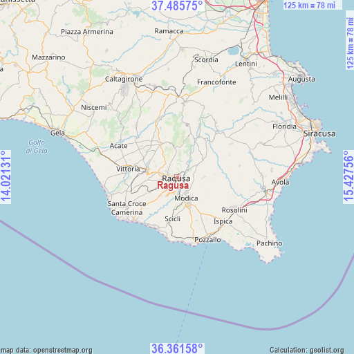
Ragusa GPS coordinates[2]
36° 55' 32.664" North, 14° 43' 27.948" East
| Map corner | latitude | longitude |
|---|---|---|
| Upper-left | 37.48575°, | 14.02131° |
| Center: | 36.92574°, | 14.72443° |
| Lower-right: | 36.36158°, | 15.42756° |
| Map W x H: | 125×125 km | = 77.7×77.7mi |
| max Lat: | 47.04031° ⇑99.8% North |
| Ragusa: | 36.92574° |
| min Lat: | ⇓0.2% South 35.50142° |
| min Long | Ragusa | max Long |
| 6.69888° | 14.72443° | 18.48682° |
| W 84.7%⇐ | ⇒15.3% E |
Elevation
Elevation of Ragusa is 540 m = 1772 ft, and this is 233.3 m = 765 ft above average elevation for this country.
| Max E: |
2085 m = 6841 ft | 18.9% |
| Ragusa | 540 m 1772 ft | |
| Avg. | 306.7 m = 1006 ft | |
Min E: |
-4 m = -13 ft | 81.1% |
See also: Ragusa elevation on elevation.city.
Geographical zone
Ragusa is located in North temperate zone (between Tropic of Cancer and the Arctic Circle). Distance of this Northern Tropic circle is 1499.8 km =931.9 mi to South.| Distance of | km | miles | from Ragusa |
|---|---|---|---|
| North Pole | 5901.3 | 3666.9 | to North |
| Arctic Circle | 3295.4 | 2047.7 | to North |
| Tropic Cancer | 1499.8 | 931.9 | to South |
| Equator | 4105.8 | 2551.2 | to South |


Nearby cities:
15 places around Ragusa: (largest is in red/bold)
• Campanella-Gianforma
9.7 km =6 mi,  89°
89°
• Cava d'Aliga
22 km =13.7 mi,  187°
187°
• Chiaramonte Gulfi
11.8 km =7.3 mi,  350°
350°
• Comiso
10.7 km =6.6 mi,  283°
283°
• Donnalucata
19.8 km =12.3 mi,  202°
202°
• Giarratana
14.9 km =9.3 mi,  24°
24°
• Marina di Ragusa
21.7 km =13.5 mi,  224°
224°
• Modica
8.1 km =5 mi,  157°
157°
• Monterosso Almo
18.5 km =11.5 mi,  11°
11°
• Pedalino
16.7 km =10.4 mi,  310°
310°
• Roccazzo
16.4 km =10.2 mi,  328°
328°
• Santa Croce Camerina
20.7 km =12.9 mi,  238°
238°
• Scicli
15.2 km =9.4 mi, 187°
• Villaggio Gulfi
13 km =8.1 mi,  343°
343°
• Vittoria
17.7 km =11 mi, 279°
Sources, notices
• [Note1] Compared only with cities in Italy existing in our database
• [Src1] Map data: © OpenStreetMap contributors (CC-BY-SA)
• [Src2] Other city data from geonames.org with taken over terms of usage.
• [Src3] Geographical zone / Annual Mean Temperature by Robert A. Rohde @ Wikipedia
