Ciavolo geodata
Ciavolo (Sicily) is a populated place; located in Italy in Europe/Rome (GMT+2) time zone. With population of 1,682 people, there are 4707 cities with bigger population in this country. Compared to other cities in Italy, 97.8% of cities are located further ↑North; 62.8% of cities are located further ←West and 65.3% of cities have higher elevation than Ciavolo. Note1


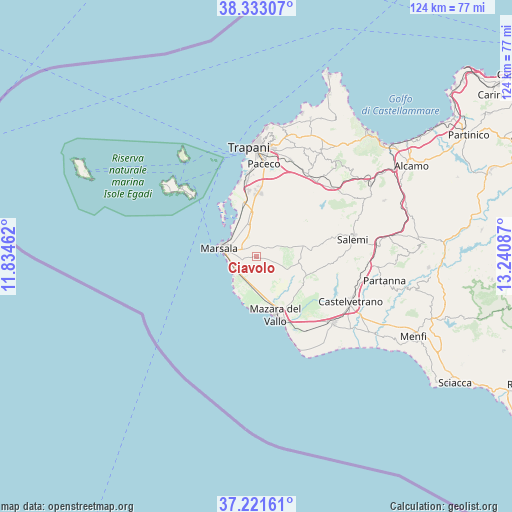
Ciavolo GPS coordinates[2]
37° 46' 45.948" North, 12° 32' 15.864" East
| Map corner | latitude | longitude |
|---|---|---|
| Upper-left | 38.33307°, | 11.83462° |
| Center: | 37.77943°, | 12.53774° |
| Lower-right: | 37.22161°, | 13.24087° |
| Map W x H: | 123.6×123.6 km | = 76.8×76.8mi |
| max Lat: | 47.04031° ⇑97.8% North |
| Ciavolo: | 37.77943° |
| min Lat: | ⇓2.2% South 35.50142° |
| min Long | Ciavolo | max Long |
| 6.69888° | 12.53774° | 18.48682° |
| W 62.8%⇐ | ⇒37.2% E |
Elevation
Elevation of Ciavolo is 126 m = 413 ft, and this is 180.7 m = 593 ft below average elevation for this country.
| Max E: |
2085 m = 6841 ft | 65.3% |
| Avg. | 306.7 m = 1006 ft | |
| Ciavolo | 126 m = 413 ft | |
Min E: |
-4 m = -13 ft | 34.7% |
See also: Italy elevation on elevation.city.
Geographical zone
Ciavolo is located in North temperate zone (between Tropic of Cancer and the Arctic Circle). Distance of this Northern Tropic circle is 1594.8 km =991 mi to South.| Distance of | km | miles | from Ciavolo |
|---|---|---|---|
| North Pole | 5806.4 | 3607.9 | to North |
| Arctic Circle | 3200.5 | 1988.7 | to North |
| Tropic Cancer | 1594.8 | 991 | to South |
| Equator | 4200.7 | 2610.2 | to South |


Nearby cities:
15 places around Ciavolo: (largest is in red/bold)
• Fulgatore-Torretta
23.3 km =14.5 mi,  35°
35°
• Guarrato
17.1 km =10.6 mi,  2°
2°
• Locogrande
16.4 km =10.2 mi,  351°
351°
• Marausa
18.2 km =11.3 mi, 352°
• Marsala
9.1 km =5.7 mi,  283°
283°
• Mazara II
12.2 km =7.6 mi,  153°
153°
• Mazara del Vallo
14.5 km =9 mi,  161°
161°
• Nubia
22.2 km =13.8 mi, 354°
• Paceco
22.4 km =13.9 mi, 4°
• Palma
19.5 km =12.1 mi, 354°
• Petrosino
8.1 km =5 mi,  204°
204°
• Rilievo
15.2 km =9.4 mi, 0°
• Salemi
24 km =14.9 mi,  78°
78°
• Salinagrande
20.2 km =12.6 mi, 353°
• San Ciro-Ulmi-Filci
22.3 km =13.9 mi,  74°
74°
Sources, notices
• [Note1] Compared only with cities in Italy existing in our database
• [Src1] Map data: © OpenStreetMap contributors (CC-BY-SA)
• [Src2] Other city data from geonames.org with taken over terms of usage.
• [Src3] Geographical zone / Annual Mean Temperature by Robert A. Rohde @ Wikipedia
