Mazara II geodata
Mazara II (Sicily) is a populated place; located in Italy in Europe/Rome (GMT+2) time zone. With population of 1,270 people, there are 5725 cities with bigger population in this country. Compared to other cities in Italy, 98.1% of cities are located further ↑North; 63.6% of cities are located further ←West and 81.5% of cities have higher elevation than Mazara II. Note1


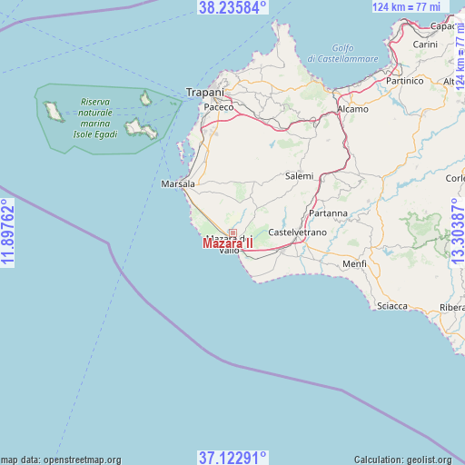
Mazara II GPS coordinates[2]
37° 40' 53.256" North, 12° 36' 2.664" East
| Map corner | latitude | longitude |
|---|---|---|
| Upper-left | 38.23584°, | 11.89762° |
| Center: | 37.68146°, | 12.60074° |
| Lower-right: | 37.12291°, | 13.30387° |
| Map W x H: | 123.7×123.7 km | = 76.9×76.9mi |
| max Lat: | 47.04031° ⇑98.1% North |
| Mazara II: | 37.68146° |
| min Lat: | ⇓1.9% South 35.50142° |
| min Long | Mazara II | max Long |
| 6.69888° | 12.60074° | 18.48682° |
| W 63.6%⇐ | ⇒36.4% E |
Elevation
Elevation of Mazara II is 44 m = 144 ft, and this is 262.7 m = 862 ft below average elevation for this country.
| Max E: |
2085 m = 6841 ft | 81.5% |
| Avg. | 306.7 m = 1006 ft | |
| Mazara II | 44 m = 144 ft | |
Min E: |
-4 m = -13 ft | 18.5% |
See also: Italy elevation on elevation.city.
Geographical zone
Mazara II is located in North temperate zone (between Tropic of Cancer and the Arctic Circle). Distance of this Northern Tropic circle is 1583.9 km =984.2 mi to South.| Distance of | km | miles | from Mazara II |
|---|---|---|---|
| North Pole | 5817.3 | 3614.7 | to North |
| Arctic Circle | 3211.4 | 1995.5 | to North |
| Tropic Cancer | 1583.9 | 984.2 | to South |
| Equator | 4189.8 | 2603.4 | to South |


Nearby cities:
15 places around Mazara II: (largest is in red/bold)
• Campobello di Mazara
14.1 km =8.8 mi,  111°
111°
• Castelvetrano
16.8 km =10.4 mi,  90°
90°
• Ciavolo
12.2 km =7.6 mi,  333°
333°
• Marinella
23.5 km =14.6 mi, 114°
• Marsala
19.5 km =12.1 mi,  312°
312°
• Mazara del Vallo
3.1 km =1.9 mi,  198°
198°
• Nuova Gibellina
27.5 km =17.1 mi,  59°
59°
• Partanna
25.9 km =16.1 mi,  78°
78°
• Petrosino
9.5 km =5.9 mi,  291°
291°
• Rilievo
26.7 km =16.6 mi,  348°
348°
• Salemi
23.8 km =14.8 mi,  48°
48°
• San Ciro-Ulmi-Filci
23.2 km =14.4 mi,  43°
43°
• Santa Ninfa
26.3 km =16.3 mi,  67°
67°
• Tre Fontane
16.5 km =10.3 mi,  138°
138°
• Triscina
19.6 km =12.2 mi,  122°
122°
Sources, notices
• [Note1] Compared only with cities in Italy existing in our database
• [Src1] Map data: © OpenStreetMap contributors (CC-BY-SA)
• [Src2] Other city data from geonames.org with taken over terms of usage.
• [Src3] Geographical zone / Annual Mean Temperature by Robert A. Rohde @ Wikipedia
