Cenadi geodata
Cenadi (Calabria) is a seat of a third-order administrative division; located in Italy in Europe/Rome (GMT+2) time zone. With population of 504 people, there are 9889 cities with bigger population in this country. Compared to other cities in Italy, 93.3% of cities are located further ↑North; 95.9% of cities are located further ←West and 79.9% of cities have lower elevation than Cenadi. Note1


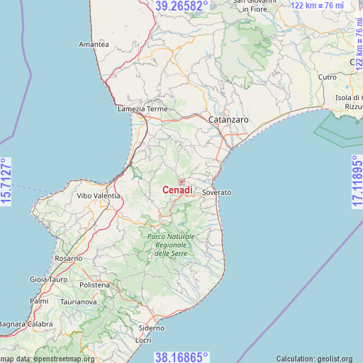
Cenadi GPS coordinates[2]
38° 43' 9.624" North, 16° 24' 56.952" East
| Map corner | latitude | longitude |
|---|---|---|
| Upper-left | 39.26582°, | 15.7127° |
| Center: | 38.71934°, | 16.41582° |
| Lower-right: | 38.16865°, | 17.11895° |
| Map W x H: | 122×122 km | = 75.8×75.8mi |
| max Lat: | 47.04031° ⇑93.3% North |
| Cenadi: | 38.71934° |
| min Lat: | ⇓6.7% South 35.50142° |
| min Long | Cenadi | max Long |
| 6.69888° | 16.41582° | 18.48682° |
| W 95.9%⇐ | ⇒4.1% E |
Elevation
Elevation of Cenadi is 524 m = 1719 ft, and this is 217.3 m = 713 ft above average elevation for this country.
| Max E: |
2085 m = 6841 ft | 20.1% |
| Cenadi | 524 m 1719 ft | |
| Avg. | 306.7 m = 1006 ft | |
Min E: |
-4 m = -13 ft | 79.9% |
See also: Italy elevation on elevation.city.
Geographical zone
Cenadi is located in North temperate zone (between Tropic of Cancer and the Arctic Circle). Distance of this Northern Tropic circle is 1699.3 km =1055.9 mi to South.| Distance of | km | miles | from Cenadi |
|---|---|---|---|
| North Pole | 5701.9 | 3543 | to North |
| Arctic Circle | 3096 | 1923.8 | to North |
| Tropic Cancer | 1699.3 | 1055.9 | to South |
| Equator | 4305.2 | 2675.1 | to South |


Nearby cities:
15 places around Cenadi: (largest is in red/bold)
• Amaroni
8.8 km =5.5 mi,  18°
18°
• Argusto
4.7 km =2.9 mi,  157°
157°
• Cardinale
7.7 km =4.8 mi,  198°
198°
• Centrache
1.7 km =1.1 mi,  51°
51°
• Chiaravalle Centrale
4.5 km =2.8 mi,  187°
187°
• Gagliato
6.2 km =3.9 mi,  141°
141°
• Gasperina
8.2 km =5.1 mi,  73°
73°
• Montepaone
7.1 km =4.4 mi,  87°
87°
• Olivadi
1 km =0.6 mi,  44°
44°
• Palermiti
4.5 km =2.8 mi, 44°
• Petrizzi
5.2 km =3.2 mi,  111°
111°
• San Vito Sullo Ionio
1.5 km =0.9 mi,  205°
205°
• Satriano
8.1 km =5 mi, 136°
• Torre di Ruggiero
8.3 km =5.2 mi, 207°
• Vallefiorita
7.5 km =4.7 mi,  31°
31°
Sources, notices
• [Note1] Compared only with cities in Italy existing in our database
• [Src1] Map data: © OpenStreetMap contributors (CC-BY-SA)
• [Src2] Other city data from geonames.org with taken over terms of usage.
• [Src3] Geographical zone / Annual Mean Temperature by Robert A. Rohde @ Wikipedia
