Caronia geodata
Caronia (Sicily) is a seat of a third-order administrative division; located in Italy in Europe/Rome (GMT+2) time zone. With population of 1,825 people, there are 4457 cities with bigger population in this country. Compared to other cities in Italy, 96.4% of cities are located further ↑North; 82.1% of cities are located further ←West and 55.1% of cities have lower elevation than Caronia. Note1


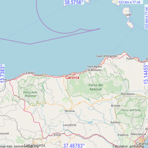
Caronia GPS coordinates[2]
38° 1' 25.716" North, 14° 26' 29.112" East
| Map corner | latitude | longitude |
|---|---|---|
| Upper-left | 38.5756°, | 13.7383° |
| Center: | 38.02381°, | 14.44142° |
| Lower-right: | 37.46783°, | 15.14455° |
| Map W x H: | 123.2×123.2 km | = 76.6×76.6mi |
| max Lat: | 47.04031° ⇑96.4% North |
| Caronia: | 38.02381° |
| min Lat: | ⇓3.6% South 35.50142° |
| min Long | Caronia | max Long |
| 6.69888° | 14.44142° | 18.48682° |
| W 82.1%⇐ | ⇒17.9% E |
Elevation
Elevation of Caronia is 266 m = 873 ft, and this is 40.7 m = 134 ft below average elevation for this country.
| Max E: |
2085 m = 6841 ft | 44.9% |
| Avg. | 306.7 m = 1006 ft | |
| Caronia | 266 m = 873 ft | |
Min E: |
-4 m = -13 ft | 55.1% |
See also: Italy elevation on elevation.city.
Geographical zone
Caronia is located in North temperate zone (between Tropic of Cancer and the Arctic Circle). Distance of this Northern Tropic circle is 1621.9 km =1007.8 mi to South.| Distance of | km | miles | from Caronia |
|---|---|---|---|
| North Pole | 5779.2 | 3591 | to North |
| Arctic Circle | 3173.3 | 1971.8 | to North |
| Tropic Cancer | 1621.9 | 1007.8 | to South |
| Equator | 4227.9 | 2627.1 | to South |


Nearby cities:
15 places around Caronia: (largest is in red/bold)
• Acquedolci
13.1 km =8.1 mi,  73°
73°
• Calarco
16.9 km =10.5 mi,  76°
76°
• Capizzi
19.8 km =12.3 mi,  170°
170°
• Castel di Lucio
19 km =11.8 mi,  216°
216°
• Castel di Tusa
16.2 km =10.1 mi,  264°
264°
• Marina di Caronia
1.3 km =0.8 mi,  1°
1°
• Militello Rosmarino
20.7 km =12.9 mi, 83°
• Mistretta
12.9 km =8 mi,  214°
214°
• Motta d'Affermo
13 km =8.1 mi,  248°
248°
• Pettineo
14.6 km =9.1 mi,  244°
244°
• Reitano
10.3 km =6.4 mi, 235°
• San Fratello
13.8 km =8.6 mi,  93°
93°
• Sant'Agata di Militello
17.7 km =11 mi, 73°
• Santo Stefano di Camastra
8 km =5 mi, 261°
• Tusa
18.5 km =11.5 mi, 256°
Sources, notices
• [Note1] Compared only with cities in Italy existing in our database
• [Src1] Map data: © OpenStreetMap contributors (CC-BY-SA)
• [Src2] Other city data from geonames.org with taken over terms of usage.
• [Src3] Geographical zone / Annual Mean Temperature by Robert A. Rohde @ Wikipedia
