Pettineo geodata
Pettineo (Sicily) is a seat of a third-order administrative division; located in Italy in Europe/Rome (GMT+2) time zone. With population of 1,362 people, there are 5466 cities with bigger population in this country. Compared to other cities in Italy, 96.9% of cities are located further ↑North; 80.8% of cities are located further ←West and 55.6% of cities have lower elevation than Pettineo. Note1


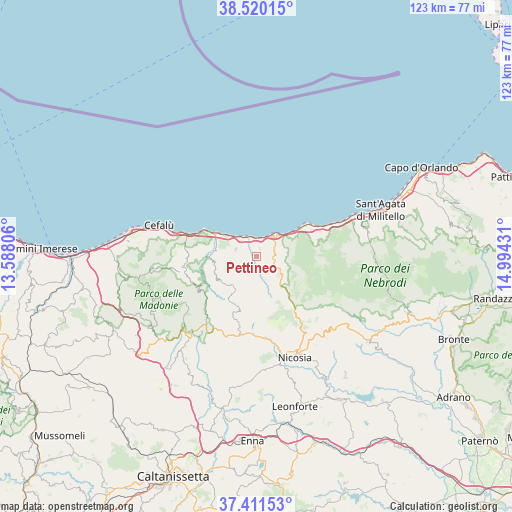
Pettineo GPS coordinates[2]
37° 58' 4.548" North, 14° 17' 28.248" East
| Map corner | latitude | longitude |
|---|---|---|
| Upper-left | 38.52015°, | 13.58806° |
| Center: | 37.96793°, | 14.29118° |
| Lower-right: | 37.41153°, | 14.99431° |
| Map W x H: | 123.3×123.3 km | = 76.6×76.6mi |
| max Lat: | 47.04031° ⇑96.9% North |
| Pettineo: | 37.96793° |
| min Lat: | ⇓3.1% South 35.50142° |
| min Long | Pettineo | max Long |
| 6.69888° | 14.29118° | 18.48682° |
| W 80.8%⇐ | ⇒19.2% E |
Elevation
Elevation of Pettineo is 269 m = 883 ft, and this is 37.7 m = 124 ft below average elevation for this country.
| Max E: |
2085 m = 6841 ft | 44.4% |
| Avg. | 306.7 m = 1006 ft | |
| Pettineo | 269 m = 883 ft | |
Min E: |
-4 m = -13 ft | 55.6% |
See also: Italy elevation on elevation.city.
Geographical zone
Pettineo is located in North temperate zone (between Tropic of Cancer and the Arctic Circle). Distance of this Northern Tropic circle is 1615.7 km =1003.9 mi to South.| Distance of | km | miles | from Pettineo |
|---|---|---|---|
| North Pole | 5785.4 | 3594.9 | to North |
| Arctic Circle | 3179.5 | 1975.6 | to North |
| Tropic Cancer | 1615.7 | 1003.9 | to South |
| Equator | 4221.6 | 2623.2 | to South |


Nearby cities:
15 places around Pettineo: (largest is in red/bold)
• Caronia
14.6 km =9.1 mi,  64°
64°
• Castel di Lucio
9.2 km =5.7 mi,  168°
168°
• Castel di Tusa
5.4 km =3.4 mi,  327°
327°
• Castelbuono
18.5 km =11.5 mi,  255°
255°
• Finale
12.7 km =7.9 mi,  296°
296°
• Gangi
20.6 km =12.8 mi,  201°
201°
• Geraci Siculo
17.1 km =10.6 mi,  224°
224°
• Marina di Caronia
15.2 km =9.4 mi, 60°
• Mistretta
7.3 km =4.5 mi,  127°
127°
• Motta d'Affermo
1.8 km =1.1 mi,  36°
36°
• Pollina
13 km =8.1 mi,  282°
282°
• Reitano
4.7 km =2.9 mi,  84°
84°
• San Mauro Castelverde
10.7 km =6.6 mi,  236°
236°
• Santo Stefano di Camastra
7.3 km =4.5 mi,  46°
46°
• Tusa
5.1 km =3.2 mi,  290°
290°
Sources, notices
• [Note1] Compared only with cities in Italy existing in our database
• [Src1] Map data: © OpenStreetMap contributors (CC-BY-SA)
• [Src2] Other city data from geonames.org with taken over terms of usage.
• [Src3] Geographical zone / Annual Mean Temperature by Robert A. Rohde @ Wikipedia
