Carolei geodata
Carolei (Calabria) is a seat of a third-order administrative division; located in Italy in Europe/Rome (GMT+2) time zone. With population of 1,320 people, there are 5572 cities with bigger population in this country. Compared to other cities in Italy, 91.6% of cities are located further ↑North; 94.6% of cities are located further ←West and 85.5% of cities have lower elevation than Carolei. Note1


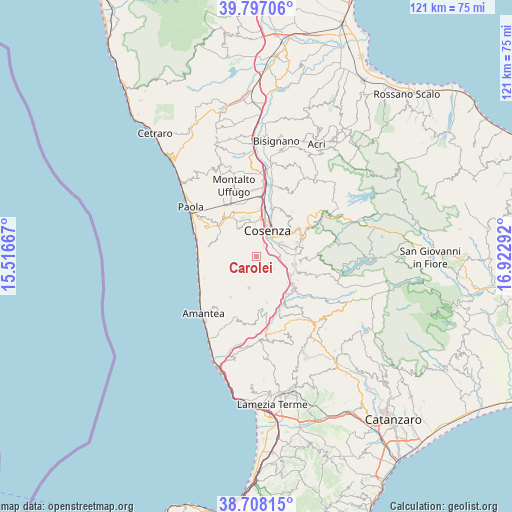
Carolei GPS coordinates[2]
39° 15' 16.992" North, 16° 13' 11.244" East
| Map corner | latitude | longitude |
|---|---|---|
| Upper-left | 39.79706°, | 15.51667° |
| Center: | 39.25472°, | 16.21979° |
| Lower-right: | 38.70815°, | 16.92292° |
| Map W x H: | 121.1×121.1 km | = 75.2×75.2mi |
| max Lat: | 47.04031° ⇑91.6% North |
| Carolei: | 39.25472° |
| min Lat: | ⇓8.4% South 35.50142° |
| min Long | Carolei | max Long |
| 6.69888° | 16.21979° | 18.48682° |
| W 94.6%⇐ | ⇒5.4% E |
Elevation
Elevation of Carolei is 622 m = 2041 ft, and this is 315.3 m = 1034 ft above average elevation for this country.
| Max E: |
2085 m = 6841 ft | 14.5% |
| Carolei | 622 m 2041 ft | |
| Avg. | 306.7 m = 1006 ft | |
Min E: |
-4 m = -13 ft | 85.5% |
See also: Italy elevation on elevation.city.
Geographical zone
Carolei is located in North temperate zone (between Tropic of Cancer and the Arctic Circle). Distance of this Northern Tropic circle is 1758.8 km =1092.9 mi to South.| Distance of | km | miles | from Carolei |
|---|---|---|---|
| North Pole | 5642.3 | 3506 | to North |
| Arctic Circle | 3036.5 | 1886.8 | to North |
| Tropic Cancer | 1758.8 | 1092.9 | to South |
| Equator | 4364.7 | 2712.1 | to South |


Nearby cities:
15 places around Carolei: (largest is in red/bold)
• Andreotta
5.9 km =3.7 mi,  358°
358°
• Cerisano
4.5 km =2.8 mi,  303°
303°
• Cosenza
5.7 km =3.5 mi,  30°
30°
• Dipignano
3.3 km =2.1 mi,  122°
122°
• Domanico
4.3 km =2.7 mi,  194°
194°
• Fontanesi-Santa Lucia
5.7 km =3.5 mi,  334°
334°
• Laurignano
3.3 km =2.1 mi,  35°
35°
• Marano Principato
6.2 km =3.9 mi,  320°
320°
• Mendicino
2.4 km =1.5 mi,  292°
292°
• Morelli Catena Sottana
6.2 km =3.9 mi,  61°
61°
• Paterno Calabro
4.9 km =3 mi,  126°
126°
• Rosario
4.2 km =2.6 mi,  13°
13°
• Serra Miceli
5.9 km =3.7 mi,  344°
344°
• Tivolille Pasquali-Merenzata
3 km =1.9 mi, 338°
• Vadue
3 km =1.9 mi,  15°
15°
Sources, notices
• [Note1] Compared only with cities in Italy existing in our database
• [Src1] Map data: © OpenStreetMap contributors (CC-BY-SA)
• [Src2] Other city data from geonames.org with taken over terms of usage.
• [Src3] Geographical zone / Annual Mean Temperature by Robert A. Rohde @ Wikipedia
