Capoterra geodata
Capoterra (Sardinia) is a seat of a third-order administrative division; located in Italy in Europe/Rome (GMT+2) time zone. With population of 11,255 people, there are 836 cities with bigger population in this country. Compared to other cities in Italy, 91.9% of cities are located further ↑North; 81.6% of cities are located further →East and 79.9% of cities have higher elevation than Capoterra. Note1


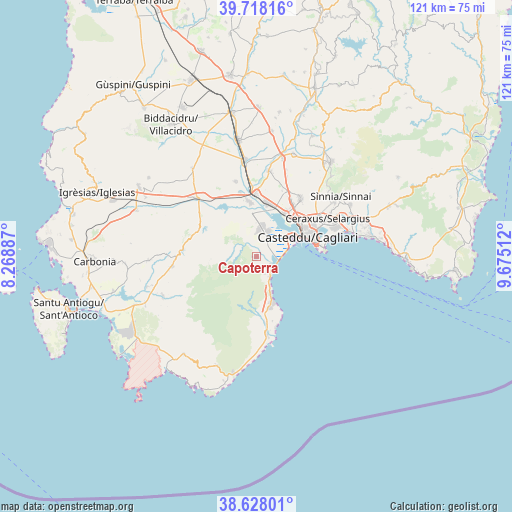
Capoterra GPS coordinates[2]
39° 10' 30.72" North, 8° 58' 19.164" East
| Map corner | latitude | longitude |
|---|---|---|
| Upper-left | 39.71816°, | 8.26887° |
| Center: | 39.1752°, | 8.97199° |
| Lower-right: | 38.62801°, | 9.67512° |
| Map W x H: | 121.2×121.2 km | = 75.3×75.3mi |
| max Lat: | 47.04031° ⇑91.9% North |
| Capoterra: | 39.1752° |
| min Lat: | ⇓8.1% South 35.50142° |
| min Long | Capoterra | max Long |
| 6.69888° | 8.97199° | 18.48682° |
| W 18.4%⇐ | ⇒81.6% E |
Elevation
Elevation of Capoterra is 50 m = 164 ft, and this is 256.7 m = 842 ft below average elevation for this country.
| Max E: |
2085 m = 6841 ft | 79.9% |
| Avg. | 306.7 m = 1006 ft | |
| Capoterra | 50 m = 164 ft | |
Min E: |
-4 m = -13 ft | 20.1% |
See also: Italy elevation on elevation.city.
Geographical zone
Capoterra is located in North temperate zone (between Tropic of Cancer and the Arctic Circle). Distance of this Northern Tropic circle is 1750 km =1087.4 mi to South.| Distance of | km | miles | from Capoterra |
|---|---|---|---|
| North Pole | 5651.2 | 3511.5 | to North |
| Arctic Circle | 3045.3 | 1892.3 | to North |
| Tropic Cancer | 1750 | 1087.4 | to South |
| Equator | 4355.9 | 2706.6 | to South |


Nearby cities:
15 places around Capoterra: (largest is in red/bold)
• Assemini
13.1 km =8.1 mi,  10°
10°
• Cagliari
14.1 km =8.8 mi,  64°
64°
• Coop. Cento
4.5 km =2.8 mi,  154°
154°
• Cortexandra
15.4 km =9.6 mi,  33°
33°
• Decimomannu
15 km =9.3 mi,  359°
359°
• Elmas
12.4 km =7.7 mi, 32°
• La Maddalena
4.9 km =3 mi,  134°
134°
• Monserrato
17.4 km =10.8 mi, 58°
• Poggio dei Pini
3.1 km =1.9 mi,  180°
180°
• Sarroch
12.6 km =7.8 mi,  165°
165°
• Sestu
17.2 km =10.7 mi,  37°
37°
• Su Planu
14.6 km =9.1 mi,  52°
52°
• Uta
13.1 km =8.1 mi,  352°
352°
• Villa San Pietro
15.7 km =9.8 mi, 172°
• Villaspeciosa
15.7 km =9.8 mi, 345°
Sources, notices
• [Note1] Compared only with cities in Italy existing in our database
• [Src1] Map data: © OpenStreetMap contributors (CC-BY-SA)
• [Src2] Other city data from geonames.org with taken over terms of usage.
• [Src3] Geographical zone / Annual Mean Temperature by Robert A. Rohde @ Wikipedia
