La Maddalena geodata
La Maddalena (Sardinia) is a populated place; located in Italy in Europe/Rome (GMT+2) time zone. With population of 7,877 people, there are 1240 cities with bigger population in this country. Compared to other cities in Italy, 92% of cities are located further ↑North; 81.1% of cities are located further →East and 96.6% of cities have higher elevation than La Maddalena. Note1


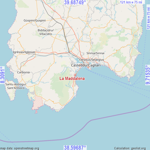
La Maddalena GPS coordinates[2]
39° 8' 39.444" North, 9° 0' 44.028" East
| Map corner | latitude | longitude |
|---|---|---|
| Upper-left | 39.68749°, | 8.3091° |
| Center: | 39.14429°, | 9.01223° |
| Lower-right: | 38.59687°, | 9.71535° |
| Map W x H: | 121.3×121.3 km | = 75.4×75.4mi |
| max Lat: | 47.04031° ⇑92% North |
| La Maddalena: | 39.14429° |
| min Lat: | ⇓8% South 35.50142° |
| min Long | La Maddalena | max Long |
| 6.69888° | 9.01223° | 18.48682° |
| W 18.9%⇐ | ⇒81.1% E |
Elevation
Elevation of La Maddalena is 6 m = 20 ft, and this is 300.7 m = 987 ft below average elevation for this country.
| Max E: |
2085 m = 6841 ft | 96.6% |
| Avg. | 306.7 m = 1006 ft | |
| La Maddalena | 6 m = 20 ft | |
Min E: |
-4 m = -13 ft | 3.4% |
See also: Italy elevation on elevation.city.
Geographical zone
La Maddalena is located in North temperate zone (between Tropic of Cancer and the Arctic Circle). Distance of this Northern Tropic circle is 1746.5 km =1085.2 mi to South.| Distance of | km | miles | from La Maddalena |
|---|---|---|---|
| North Pole | 5654.6 | 3513.6 | to North |
| Arctic Circle | 3048.7 | 1894.4 | to North |
| Tropic Cancer | 1746.5 | 1085.2 | to South |
| Equator | 4352.4 | 2704.5 | to South |


Nearby cities:
15 places around La Maddalena: (largest is in red/bold)
• Assemini
16.4 km =10.2 mi,  355°
355°
• Cagliari
13.3 km =8.3 mi,  43°
43°
• Capoterra
4.9 km =3 mi,  314°
314°
• Coop. Cento
1.6 km =1 mi,  246°
246°
• Cortexandra
17.1 km =10.6 mi,  17°
17°
• Elmas
14.2 km =8.8 mi,  13°
13°
• Monserrato
16.9 km =10.5 mi, 42°
• Poggio dei Pini
3.5 km =2.2 mi,  275°
275°
• Pula
15.3 km =9.5 mi,  183°
183°
• Sarroch
8.7 km =5.4 mi, 181°
• Selargius
18.1 km =11.2 mi,  45°
45°
• Sestu
18.5 km =11.5 mi, 21°
• Su Planu
14.7 km =9.1 mi,  33°
33°
• Uta
17.2 km =10.7 mi,  342°
342°
• Villa San Pietro
12.2 km =7.6 mi,  186°
186°
Sources, notices
• [Note1] Compared only with cities in Italy existing in our database
• [Src1] Map data: © OpenStreetMap contributors (CC-BY-SA)
• [Src2] Other city data from geonames.org with taken over terms of usage.
• [Src3] Geographical zone / Annual Mean Temperature by Robert A. Rohde @ Wikipedia
