Borgetto geodata
Borgetto (Sicily) is a seat of a third-order administrative division; located in Italy in Europe/Rome (GMT+2) time zone. With population of 6,272 people, there are 1558 cities with bigger population in this country. Compared to other cities in Italy, 96.2% of cities are located further ↑North; 69.8% of cities are located further ←West and 57.1% of cities have lower elevation than Borgetto. Note1


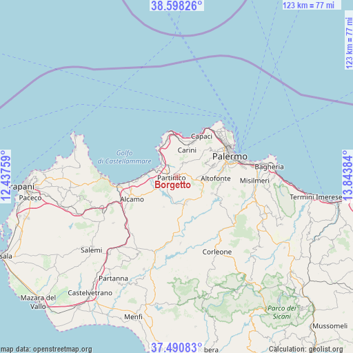
Borgetto GPS coordinates[2]
38° 2' 47.904" North, 13° 8' 26.556" East
| Map corner | latitude | longitude |
|---|---|---|
| Upper-left | 38.59826°, | 12.43759° |
| Center: | 38.04664°, | 13.14071° |
| Lower-right: | 37.49083°, | 13.84384° |
| Map W x H: | 123.1×123.1 km | = 76.5×76.5mi |
| max Lat: | 47.04031° ⇑96.2% North |
| Borgetto: | 38.04664° |
| min Lat: | ⇓3.8% South 35.50142° |
| min Long | Borgetto | max Long |
| 6.69888° | 13.14071° | 18.48682° |
| W 69.8%⇐ | ⇒30.2% E |
Elevation
Elevation of Borgetto is 279 m = 915 ft, and this is 27.7 m = 91 ft below average elevation for this country.
| Max E: |
2085 m = 6841 ft | 42.9% |
| Avg. | 306.7 m = 1006 ft | |
| Borgetto | 279 m = 915 ft | |
Min E: |
-4 m = -13 ft | 57.1% |
See also: Italy elevation on elevation.city.
Geographical zone
Borgetto is located in North temperate zone (between Tropic of Cancer and the Arctic Circle). Distance of this Northern Tropic circle is 1624.5 km =1009.4 mi to South.| Distance of | km | miles | from Borgetto |
|---|---|---|---|
| North Pole | 5776.7 | 3589.5 | to North |
| Arctic Circle | 3170.8 | 1970.2 | to North |
| Tropic Cancer | 1624.5 | 1009.4 | to South |
| Equator | 4230.4 | 2628.6 | to South |


Nearby cities:
15 places around Borgetto: (largest is in red/bold)
• Agliandroni-Paternella
11.5 km =7.1 mi,  326°
326°
• Balestrate
11.7 km =7.3 mi,  272°
272°
• Cannizzaro-Favara
11.6 km =7.2 mi,  81°
81°
• Carini
10.2 km =6.3 mi,  21°
21°
• Giacalone
8.6 km =5.3 mi,  100°
100°
• Giardinello
4.7 km =2.9 mi, 17°
• Grisì
11.3 km =7 mi,  203°
203°
• Montelepre
5.7 km =3.5 mi,  31°
31°
• Partinico
2 km =1.2 mi, 269°
• Pioppo
8.1 km =5 mi,  87°
87°
• San Cipirello
10.1 km =6.3 mi,  161°
161°
• San Giuseppe Jato
9.2 km =5.7 mi,  152°
152°
• San Martino delle Scale
11.1 km =6.9 mi,  63°
63°
• Terrasini
12.2 km =7.6 mi,  335°
335°
• Trappeto
9.3 km =5.8 mi,  285°
285°
Sources, notices
• [Note1] Compared only with cities in Italy existing in our database
• [Src1] Map data: © OpenStreetMap contributors (CC-BY-SA)
• [Src2] Other city data from geonames.org with taken over terms of usage.
• [Src3] Geographical zone / Annual Mean Temperature by Robert A. Rohde @ Wikipedia
