Aragona geodata
Aragona (Sicily) is a seat of a third-order administrative division; located in Italy in Europe/Rome (GMT+2) time zone. With population of 8,779 people, there are 1085 cities with bigger population in this country. Compared to other cities in Italy, 99.1% of cities are located further ↑North; 74.8% of cities are located further ←West and 65.1% of cities have lower elevation than Aragona. Note1


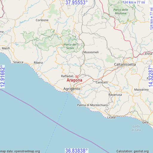
Aragona GPS coordinates[2]
37° 23' 56.544" North, 13° 37' 11.064" East
| Map corner | latitude | longitude |
|---|---|---|
| Upper-left | 37.95553°, | 12.91662° |
| Center: | 37.39904°, | 13.61974° |
| Lower-right: | 36.83838°, | 14.32287° |
| Map W x H: | 124.2×124.2 km | = 77.2×77.2mi |
| max Lat: | 47.04031° ⇑99.1% North |
| Aragona: | 37.39904° |
| min Lat: | ⇓0.9% South 35.50142° |
| min Long | Aragona | max Long |
| 6.69888° | 13.61974° | 18.48682° |
| W 74.8%⇐ | ⇒25.2% E |
Elevation
Elevation of Aragona is 344 m = 1129 ft, and this is 37.3 m = 122 ft above average elevation for this country.
| Max E: |
2085 m = 6841 ft | 34.9% |
| Aragona | 344 m 1129 ft | |
| Avg. | 306.7 m = 1006 ft | |
Min E: |
-4 m = -13 ft | 65.1% |
See also: Italy elevation on elevation.city.
Geographical zone
Aragona is located in North temperate zone (between Tropic of Cancer and the Arctic Circle). Distance of this Northern Tropic circle is 1552.5 km =964.7 mi to South.| Distance of | km | miles | from Aragona |
|---|---|---|---|
| North Pole | 5848.7 | 3634.2 | to North |
| Arctic Circle | 3242.8 | 2015 | to North |
| Tropic Cancer | 1552.5 | 964.7 | to South |
| Equator | 4158.4 | 2583.9 | to South |


Nearby cities:
15 places around Aragona: (largest is in red/bold)
• Agrigento
10.5 km =6.5 mi,  201°
201°
• Castrofilippo
12.7 km =7.9 mi,  115°
115°
• Comitini
2.4 km =1.5 mi,  67°
67°
• Favara
9.8 km =6.1 mi,  157°
157°
• Giardina Gallotti
10.1 km =6.3 mi,  237°
237°
• Grotte
7 km =4.3 mi,  85°
85°
• Joppolo Giancaxio
5.8 km =3.6 mi,  256°
256°
• Milena
13 km =8.1 mi,  51°
51°
• Porto Empedocle
14.8 km =9.2 mi,  214°
214°
• Racalmuto
9.8 km =6.1 mi, 86°
• Raffadali
7.8 km =4.8 mi,  272°
272°
• San Biagio Platani
14.7 km =9.1 mi,  326°
326°
• Sant'Angelo Muxaro
11.1 km =6.9 mi,  324°
324°
• Santa Elisabetta
6.9 km =4.3 mi,  301°
301°
• Villaseta
12.4 km =7.7 mi, 205°
Sources, notices
• [Note1] Compared only with cities in Italy existing in our database
• [Src1] Map data: © OpenStreetMap contributors (CC-BY-SA)
• [Src2] Other city data from geonames.org with taken over terms of usage.
• [Src3] Geographical zone / Annual Mean Temperature by Robert A. Rohde @ Wikipedia
