Favara geodata
Favara (Sicily) is a seat of a third-order administrative division; located in Italy in Europe/Rome (GMT+2) time zone. With population of 32,110 people, there are 251 cities with bigger population in this country. Compared to other cities in Italy, 99.2% of cities are located further ↑North; 75.3% of cities are located further ←West and 62.3% of cities have lower elevation than Favara. Note1


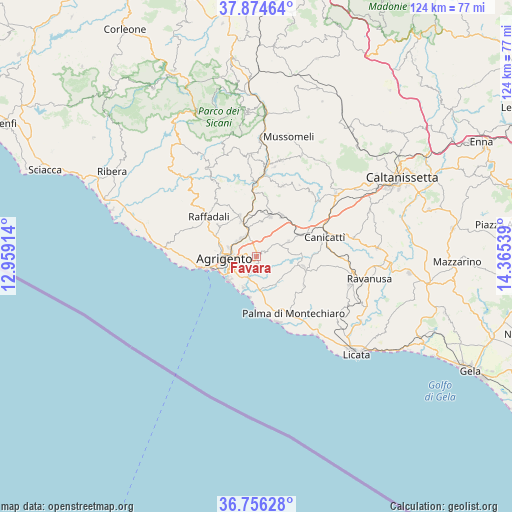
Favara GPS coordinates[2]
37° 19' 3.144" North, 13° 39' 44.136" East
| Map corner | latitude | longitude |
|---|---|---|
| Upper-left | 37.87464°, | 12.95914° |
| Center: | 37.31754°, | 13.66226° |
| Lower-right: | 36.75628°, | 14.36539° |
| Map W x H: | 124.3×124.4 km | = 77.2×77.3mi |
| max Lat: | 47.04031° ⇑99.2% North |
| Favara: | 37.31754° |
| min Lat: | ⇓0.8% South 35.50142° |
| min Long | Favara | max Long |
| 6.69888° | 13.66226° | 18.48682° |
| W 75.3%⇐ | ⇒24.7% E |
Elevation
Elevation of Favara is 317 m = 1040 ft, and this is 10.3 m = 34 ft above average elevation for this country.
| Max E: |
2085 m = 6841 ft | 37.7% |
| Favara | 317 m 1040 ft | |
| Avg. | 306.7 m = 1006 ft | |
Min E: |
-4 m = -13 ft | 62.3% |
See also: Italy elevation on elevation.city.
Geographical zone
Favara is located in North temperate zone (between Tropic of Cancer and the Arctic Circle). Distance of this Northern Tropic circle is 1543.4 km =959 mi to South.| Distance of | km | miles | from Favara |
|---|---|---|---|
| North Pole | 5857.7 | 3639.8 | to North |
| Arctic Circle | 3251.9 | 2020.6 | to North |
| Tropic Cancer | 1543.4 | 959 | to South |
| Equator | 4149.3 | 2578.3 | to South |


Nearby cities:
15 places around Favara: (largest is in red/bold)
• Agrigento
7.6 km =4.7 mi,  264°
264°
• Aragona
9.8 km =6.1 mi,  337°
337°
• Camastra
13.5 km =8.4 mi,  121°
121°
• Castrofilippo
8.6 km =5.3 mi,  64°
64°
• Comitini
10.1 km =6.3 mi,  351°
351°
• Giardina Gallotti
12.9 km =8 mi,  286°
286°
• Grotte
10.1 km =6.3 mi,  18°
18°
• Joppolo Giancaxio
12.2 km =7.6 mi,  309°
309°
• Naro
11.9 km =7.4 mi,  103°
103°
• Porto Empedocle
12.5 km =7.8 mi, 255°
• Racalmuto
11.4 km =7.1 mi,  31°
31°
• Raffadali
14.9 km =9.3 mi, 309°
• San Leone Mosè
9 km =5.6 mi,  229°
229°
• Santa Elisabetta
15.9 km =9.9 mi,  322°
322°
• Villaseta
9.4 km =5.8 mi, 257°
Sources, notices
• [Note1] Compared only with cities in Italy existing in our database
• [Src1] Map data: © OpenStreetMap contributors (CC-BY-SA)
• [Src2] Other city data from geonames.org with taken over terms of usage.
• [Src3] Geographical zone / Annual Mean Temperature by Robert A. Rohde @ Wikipedia
