Alì geodata
Alì (Sicily) is a seat of a third-order administrative division; located in Italy in Europe/Rome (GMT+2) time zone. With population of 778 people, there are 7773 cities with bigger population in this country. Compared to other cities in Italy, 96.4% of cities are located further ↑North; 90.3% of cities are located further ←West and 73.9% of cities have lower elevation than Alì. Note1


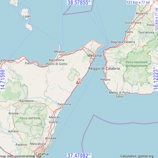
Alì GPS coordinates[2]
38° 1' 36.408" North, 15° 25' 8.76" East
| Map corner | latitude | longitude |
|---|---|---|
| Upper-left | 38.57855°, | 14.71598° |
| Center: | 38.02678°, | 15.4191° |
| Lower-right: | 37.47082°, | 16.12223° |
| Map W x H: | 123.2×123.2 km | = 76.6×76.6mi |
| max Lat: | 47.04031° ⇑96.4% North |
| Alì: | 38.02678° |
| min Lat: | ⇓3.6% South 35.50142° |
| min Long | Alì | max Long |
| 6.69888° | 15.4191° | 18.48682° |
| W 90.3%⇐ | ⇒9.7% E |
Elevation
Elevation of Alì is 438 m = 1437 ft, and this is 131.3 m = 431 ft above average elevation for this country.
| Max E: |
2085 m = 6841 ft | 26.1% |
| Alì | 438 m 1437 ft | |
| Avg. | 306.7 m = 1006 ft | |
Min E: |
-4 m = -13 ft | 73.9% |
See also: Italy elevation on elevation.city.
Geographical zone
Alì is located in North temperate zone (between Tropic of Cancer and the Arctic Circle). Distance of this Northern Tropic circle is 1622.3 km =1008.1 mi to South.| Distance of | km | miles | from Alì |
|---|---|---|---|
| North Pole | 5778.9 | 3590.8 | to North |
| Arctic Circle | 3173 | 1971.6 | to North |
| Tropic Cancer | 1622.3 | 1008.1 | to South |
| Equator | 4228.2 | 2627.3 | to South |


Nearby cities:
15 places around Alì: (largest is in red/bold)
• Alì Terme
2.4 km =1.5 mi,  172°
172°
• Fiumedinisi
3.3 km =2.1 mi,  268°
268°
• Furci Siculo
8.1 km =5 mi,  206°
206°
• Giampilieri
6.4 km =4 mi,  44°
44°
• Guidomandri Marina
4.4 km =2.7 mi,  61°
61°
• Itala
3.2 km =2 mi,  29°
29°
• Itala Marina
3.1 km =1.9 mi,  69°
69°
• Mandanici
9.3 km =5.8 mi,  253°
253°
• Nizza di Sicilia
4.1 km =2.5 mi,  191°
191°
• Pagliara
6.9 km =4.3 mi,  228°
228°
• Roccalumera
6.1 km =3.8 mi,  200°
200°
• Rocchenere
6.9 km =4.3 mi, 212°
• Santa Teresa di Riva
10.1 km =6.3 mi, 207°
• Savoca
10.7 km =6.6 mi,  220°
220°
• Scaletta Zanclea
4.9 km =3 mi, 61°
Sources, notices
• [Note1] Compared only with cities in Italy existing in our database
• [Src1] Map data: © OpenStreetMap contributors (CC-BY-SA)
• [Src2] Other city data from geonames.org with taken over terms of usage.
• [Src3] Geographical zone / Annual Mean Temperature by Robert A. Rohde @ Wikipedia
