Rocchenere geodata
Rocchenere (Sicily) is a populated place; located in Italy in Europe/Rome (GMT+2) time zone. With population of 701 people, there are 8293 cities with bigger population in this country. Compared to other cities in Italy, 96.8% of cities are located further ↑North; 90% of cities are located further ←West and 72.5% of cities have higher elevation than Rocchenere. Note1


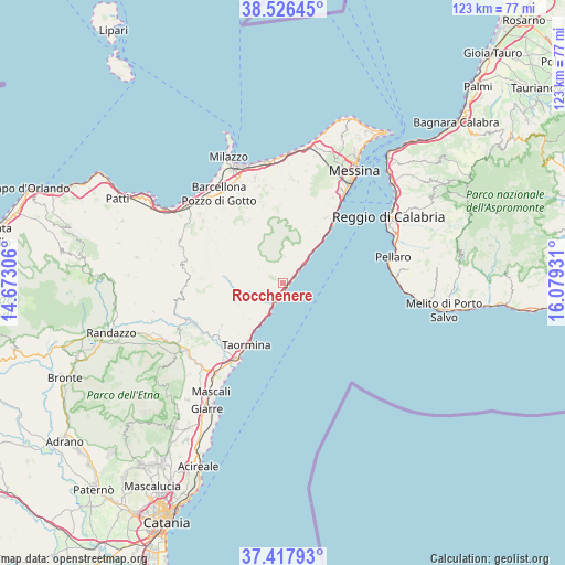
Rocchenere GPS coordinates[2]
37° 58' 27.408" North, 15° 22' 34.248" East
| Map corner | latitude | longitude |
|---|---|---|
| Upper-left | 38.52645°, | 14.67306° |
| Center: | 37.97428°, | 15.37618° |
| Lower-right: | 37.41793°, | 16.07931° |
| Map W x H: | 123.3×123.3 km | = 76.6×76.6mi |
| max Lat: | 47.04031° ⇑96.8% North |
| Rocchenere: | 37.97428° |
| min Lat: | ⇓3.2% South 35.50142° |
| min Long | Rocchenere | max Long |
| 6.69888° | 15.37618° | 18.48682° |
| W 90%⇐ | ⇒10% E |
Elevation
Elevation of Rocchenere is 85 m = 279 ft, and this is 221.7 m = 727 ft below average elevation for this country.
| Max E: |
2085 m = 6841 ft | 72.5% |
| Avg. | 306.7 m = 1006 ft | |
| Rocchenere | 85 m = 279 ft | |
Min E: |
-4 m = -13 ft | 27.5% |
See also: Italy elevation on elevation.city.
Geographical zone
Rocchenere is located in North temperate zone (between Tropic of Cancer and the Arctic Circle). Distance of this Northern Tropic circle is 1616.4 km =1004.4 mi to South.| Distance of | km | miles | from Rocchenere |
|---|---|---|---|
| North Pole | 5784.7 | 3594.4 | to North |
| Arctic Circle | 3178.8 | 1975.2 | to North |
| Tropic Cancer | 1616.4 | 1004.4 | to South |
| Equator | 4222.3 | 2623.6 | to South |


Nearby cities:
15 places around Rocchenere: (largest is in red/bold)
• Alì
6.9 km =4.3 mi,  32°
32°
• Alì Terme
5.3 km =3.3 mi,  49°
49°
• Casalvecchio Siculo
4.9 km =3 mi,  249°
249°
• Fiumedinisi
5.8 km =3.6 mi,  4°
4°
• Forza d'Agrò
7.5 km =4.7 mi,  209°
209°
• Furci Siculo
1.4 km =0.9 mi,  174°
174°
• Itala Marina
9.7 km =6 mi,  43°
43°
• Mandanici
6.1 km =3.8 mi,  301°
301°
• Nizza di Sicilia
3.5 km =2.2 mi,  57°
57°
• Pagliara
1.9 km =1.2 mi,  310°
310°
• Rina
5.1 km =3.2 mi,  226°
226°
• Roccalumera
1.6 km =1 mi,  84°
84°
• Sant'Alessio Siculo
5.9 km =3.7 mi,  203°
203°
• Santa Teresa di Riva
3.2 km =2 mi,  194°
194°
• Savoca
3.9 km =2.4 mi, 233°
Sources, notices
• [Note1] Compared only with cities in Italy existing in our database
• [Src1] Map data: © OpenStreetMap contributors (CC-BY-SA)
• [Src2] Other city data from geonames.org with taken over terms of usage.
• [Src3] Geographical zone / Annual Mean Temperature by Robert A. Rohde @ Wikipedia
