Alessandria del Carretto geodata
Alessandria del Carretto (Calabria) is a seat of a third-order administrative division; located in Italy in Europe/Rome (GMT+2) time zone. With population of 523 people, there are 9703 cities with bigger population in this country. Compared to other cities in Italy, 88.2% of cities are located further ↑North; 95.7% of cities are located further ←West and 97% of cities have lower elevation than Alessandria del Carretto. Note1
Administrative division(s):
- Level 1: Calabria
- Level 2: Provincia di Cosenza
- Level 3: Alessandria del Carretto
Current local time in Alessandria del Carretto:
08:28 PM, WednesdayDifference from your time zone: hours


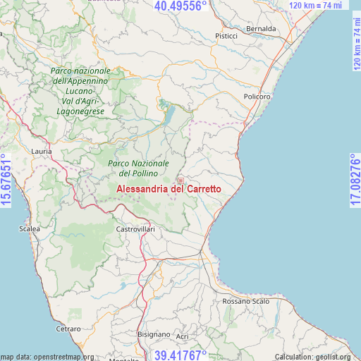
Alessandria del Carretto GPS coordinates[2]
39° 57' 31.464" North, 16° 22' 46.668" East
| Map corner | latitude | longitude |
|---|---|---|
| Upper-left | 40.49556°, | 15.67651° |
| Center: | 39.95874°, | 16.37963° |
| Lower-right: | 39.41767°, | 17.08276° |
| Map W x H: | 119.9×119.9 km | = 74.5×74.5mi |
| max Lat: | 47.04031° ⇑88.2% North |
| Alessandria del Carretto: | 39.95874° |
| min Lat: | ⇓11.8% South 35.50142° |
| min Long | Alessandria del | max Long |
| 6.69888° | 16.37963° | 18.48682° |
| W 95.7%⇐ | ⇒4.3% E |
Elevation
Elevation of Alessandria del Carretto is 997 m = 3271 ft, and this is 690.3 m = 2265 ft above average elevation for this country.
| Max E: |
2085 m = 6841 ft | 3% |
| Alessandria del Carretto | 997 m 3271 ft | |
| Avg. | 306.7 m = 1006 ft | |
Min E: |
-4 m = -13 ft | 97% |
See also: Italy elevation on elevation.city.
Geographical zone
Alessandria del Carretto is located in North temperate zone (between Tropic of Cancer and the Arctic Circle). Distance of this Northern Tropic circle is 1837.1 km =1141.5 mi to South.| Distance of | km | miles | from Alessandria del Carretto |
|---|---|---|---|
| North Pole | 5564.1 | 3457.4 | to North |
| Arctic Circle | 2958.2 | 1838.1 | to North |
| Tropic Cancer | 1837.1 | 1141.5 | to South |
| Equator | 4443 | 2760.8 | to South |


Nearby cities:
15 places around Alessandria del Carretto: (largest is in red/bold)
• Albidona
8.8 km =5.5 mi,  116°
116°
• Castroregio
9.2 km =5.7 mi,  66°
66°
• Cerchiara di Calabria
11 km =6.8 mi,  178°
178°
• Cersosimo
10.1 km =6.3 mi,  345°
345°
• Civita
15.6 km =9.7 mi,  201°
201°
• Francavilla Marittima
15.9 km =9.9 mi, 175°
• Montegiordano
16.2 km =10.1 mi,  54°
54°
• Noepoli
14.9 km =9.3 mi,  342°
342°
• Oriolo
12 km =7.5 mi,  28°
28°
• Plataci
7.9 km =4.9 mi,  145°
145°
• San Costantino Albanese
10.8 km =6.7 mi,  323°
323°
• San Lorenzo Bellizzi
8.9 km =5.5 mi,  208°
208°
• San Paolo Albanese
9.4 km =5.8 mi, 336°
• Terranova di Pollino
7.4 km =4.6 mi,  286°
286°
• Villapiana
14.1 km =8.8 mi, 152°
Sources, notices
• [Note1] Compared only with cities in Italy existing in our database
• [Src1] Map data: © OpenStreetMap contributors (CC-BY-SA)
• [Src2] Other city data from geonames.org with taken over terms of usage.
• [Src3] Geographical zone / Annual Mean Temperature by Robert A. Rohde @ Wikipedia
