San Costantino Albanese geodata
San Costantino Albanese (Basilicate) is a seat of a third-order administrative division; located in Italy in Europe/Rome (GMT+2) time zone. With population of 534 people, there are 9605 cities with bigger population in this country. Compared to other cities in Italy, 87.7% of cities are located further ↑North; 95.2% of cities are located further ←West and 86.8% of cities have lower elevation than San Costantino Albanese. Note1
Administrative division(s):
- Level 1: Basilicate
- Level 2: Provincia di Potenza
- Level 3: San Costantino Albanese
Current local time in San Costantino Albanese:
10:13 PM, WednesdayDifference from your time zone: hours


San Costantino Albanese GPS coordinates[2]
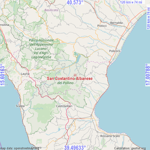
40° 2' 12.444" North, 16° 18' 17.1" East
| Map corner | latitude | longitude |
|---|---|---|
| Upper-left | 40.573°, | 15.60163° |
| Center: | 40.03679°, | 16.30475° |
| Lower-right: | 39.49633°, | 17.00788° |
| Map W x H: | 119.7×119.7 km | = 74.4×74.4mi |
| max Lat: | 47.04031° ⇑87.7% North |
| San Costantino Albanese: | 40.03679° |
| min Lat: | ⇓12.3% South 35.50142° |
| min Long | San Costantino | max Long |
| 6.69888° | 16.30475° | 18.48682° |
| W 95.2%⇐ | ⇒4.8% E |
Elevation
Elevation of San Costantino Albanese is 648 m = 2126 ft, and this is 341.3 m = 1120 ft above average elevation for this country.
| Max E: |
2085 m = 6841 ft | 13.2% |
| San Costantino Albanese | 648 m 2126 ft | |
| Avg. | 306.7 m = 1006 ft | |
Min E: |
-4 m = -13 ft | 86.8% |
See also: Italy elevation on elevation.city.
Geographical zone
San Costantino Albanese is located in North temperate zone (between Tropic of Cancer and the Arctic Circle). Distance of this Northern Tropic circle is 1845.8 km =1146.9 mi to South.| Distance of | km | miles | from San Costantino Albanese |
|---|---|---|---|
| North Pole | 5555.4 | 3452 | to North |
| Arctic Circle | 2949.5 | 1832.7 | to North |
| Tropic Cancer | 1845.8 | 1146.9 | to South |
| Equator | 4451.7 | 2766.2 | to South |


Nearby cities:
15 places around San Costantino Albanese: (largest is in red/bold)
• Alessandria del Carretto
10.8 km =6.7 mi,  143°
143°
• Castroregio
15.6 km =9.7 mi,  108°
108°
• Cersosimo
4.1 km =2.5 mi,  73°
73°
• Chiaromonte
12.3 km =7.6 mi,  321°
321°
• Fardella
14.3 km =8.9 mi,  306°
306°
• Francavilla in Sinni
9.9 km =6.2 mi,  300°
300°
• Nocara
16.6 km =10.3 mi, 65°
• Noepoli
5.9 km =3.7 mi,  19°
19°
• Oriolo
12.2 km =7.6 mi,  81°
81°
• San Giorgio Lucano
11 km =6.8 mi,  40°
40°
• San Paolo Albanese
2.6 km =1.6 mi,  92°
92°
• San Severino Lucano
14.3 km =8.9 mi,  262°
262°
• Senise
12.2 km =7.6 mi,  353°
353°
• Teana
16.3 km =10.1 mi, 307°
• Terranova di Pollino
6.6 km =4.1 mi,  186°
186°
Sources, notices
• [Note1] Compared only with cities in Italy existing in our database
• [Src1] Map data: © OpenStreetMap contributors (CC-BY-SA)
• [Src2] Other city data from geonames.org with taken over terms of usage.
• [Src3] Geographical zone / Annual Mean Temperature by Robert A. Rohde @ Wikipedia
