Veleso geodata
Veleso (Lombardy) is a seat of a third-order administrative division; located in Italy in Europe/Rome (GMT+2) time zone. With population of 216 people, there are 11051 cities with bigger population in this country. Compared to other cities in Italy, 89.5% of cities are located further ↓South; 78.4% of cities are located further →East and 94.2% of cities have lower elevation than Veleso. Note1


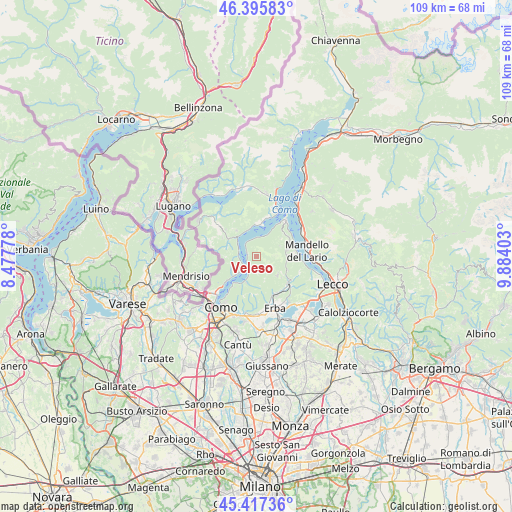
Veleso GPS coordinates[2]
45° 54' 31.5" North, 9° 10' 51.24" East
| Map corner | latitude | longitude |
|---|---|---|
| Upper-left | 46.39583°, | 8.47778° |
| Center: | 45.90875°, | 9.1809° |
| Lower-right: | 45.41736°, | 9.88403° |
| Map W x H: | 108.8×108.8 km | = 67.6×67.6mi |
| max Lat: | 47.04031° ⇑10.5% North |
| Veleso: | 45.90875° |
| min Lat: | ⇓89.5% South 35.50142° |
| min Long | Veleso | max Long |
| 6.69888° | 9.1809° | 18.48682° |
| W 21.6%⇐ | ⇒78.4% E |
Elevation
Elevation of Veleso is 845 m = 2772 ft, and this is 538.3 m = 1766 ft above average elevation for this country.
| Max E: |
2085 m = 6841 ft | 5.8% |
| Veleso | 845 m 2772 ft | |
| Avg. | 306.7 m = 1006 ft | |
Min E: |
-4 m = -13 ft | 94.2% |
See also: Italy elevation on elevation.city.
Geographical zone
Veleso is located in North temperate zone (between Tropic of Cancer and the Arctic Circle). Distance of this North polar circle is 2296.6 km =1427 mi to North.| Distance of | km | miles | from Veleso |
|---|---|---|---|
| North Pole | 4902.5 | 3046.3 | to North |
| Arctic Circle | 2296.6 | 1427 | to North |
| Tropic Cancer | 2498.7 | 1552.6 | to South |
| Equator | 5104.6 | 3171.9 | to South |


Nearby cities:
15 places around Veleso: (largest is in red/bold)
• Argegno
5.6 km =3.5 mi,  311°
311°
• Brienno
3.8 km =2.4 mi,  274°
274°
• Caglio
6 km =3.7 mi,  133°
133°
• Carate Urio
6.1 km =3.8 mi,  227°
227°
• Colonno
5.9 km =3.7 mi,  338°
338°
• Faggeto Lario
5.8 km =3.6 mi,  197°
197°
• Laglio
4.6 km =2.9 mi, 227°
• Lemna
5.9 km =3.7 mi, 196°
• Lezzeno
3.9 km =2.4 mi,  4°
4°
• Magreglio
6.5 km =4 mi,  77°
77°
• Nesso
1.9 km =1.2 mi,  282°
282°
• Pognana Lario
3.6 km =2.2 mi,  209°
209°
• Sala Comacina
6.3 km =3.9 mi,  349°
349°
• Sormano
6.1 km =3.8 mi,  124°
124°
• Zelbio
0.5 km =0.3 mi,  183°
183°
Sources, notices
• [Note1] Compared only with cities in Italy existing in our database
• [Src1] Map data: © OpenStreetMap contributors (CC-BY-SA)
• [Src2] Other city data from geonames.org with taken over terms of usage.
• [Src3] Geographical zone / Annual Mean Temperature by Robert A. Rohde @ Wikipedia
