Magreglio geodata
Magreglio (Lombardy) is a seat of a third-order administrative division; located in Italy in Europe/Rome (GMT+2) time zone. With population of 645 people, there are 8670 cities with bigger population in this country. Compared to other cities in Italy, 89.9% of cities are located further ↓South; 77.1% of cities are located further →East and 91.2% of cities have lower elevation than Magreglio. Note1


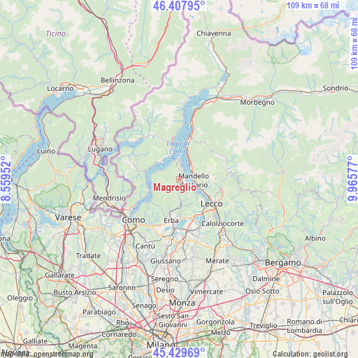
Magreglio GPS coordinates[2]
45° 55' 15.528" North, 9° 15' 45.504" East
| Map corner | latitude | longitude |
|---|---|---|
| Upper-left | 46.40795°, | 8.55952° |
| Center: | 45.92098°, | 9.26264° |
| Lower-right: | 45.42969°, | 9.96577° |
| Map W x H: | 108.8×108.8 km | = 67.6×67.6mi |
| max Lat: | 47.04031° ⇑10.1% North |
| Magreglio: | 45.92098° |
| min Lat: | ⇓89.9% South 35.50142° |
| min Long | Magreglio | max Long |
| 6.69888° | 9.26264° | 18.48682° |
| W 22.9%⇐ | ⇒77.1% E |
Elevation
Elevation of Magreglio is 749 m = 2457 ft, and this is 442.3 m = 1451 ft above average elevation for this country.
| Max E: |
2085 m = 6841 ft | 8.8% |
| Magreglio | 749 m 2457 ft | |
| Avg. | 306.7 m = 1006 ft | |
Min E: |
-4 m = -13 ft | 91.2% |
See also: Italy elevation on elevation.city.
Geographical zone
Magreglio is located in North temperate zone (between Tropic of Cancer and the Arctic Circle). Distance of this North polar circle is 2295.2 km =1426.2 mi to North.| Distance of | km | miles | from Magreglio |
|---|---|---|---|
| North Pole | 4901.1 | 3045.4 | to North |
| Arctic Circle | 2295.2 | 1426.2 | to North |
| Tropic Cancer | 2500 | 1553.4 | to South |
| Equator | 5105.9 | 3172.7 | to South |


Nearby cities:
15 places around Magreglio: (largest is in red/bold)
• Abbadia Lariana
6.1 km =3.8 mi,  113°
113°
• Barni
1.1 km =0.7 mi,  166°
166°
• Caglio
5.8 km =3.6 mi,  199°
199°
• Civenna
2.2 km =1.4 mi,  17°
17°
• Crebbio
5.6 km =3.5 mi,  99°
99°
• Lasnigo
4.3 km =2.7 mi,  176°
176°
• Lezzeno
6.5 km =4 mi,  293°
293°
• Lierna
5.3 km =3.3 mi,  38°
38°
• Mandello del Lario
4.4 km =2.7 mi,  88°
88°
• Osigo
5.7 km =3.5 mi,  153°
153°
• Rezzago
6.1 km =3.8 mi,  190°
190°
• Sormano
4.9 km =3 mi, 195°
• Valbrona
5.6 km =3.5 mi, 149°
• Vassena
1.9 km =1.2 mi,  58°
58°
• Veleso
6.5 km =4 mi,  257°
257°
Sources, notices
• [Note1] Compared only with cities in Italy existing in our database
• [Src1] Map data: © OpenStreetMap contributors (CC-BY-SA)
• [Src2] Other city data from geonames.org with taken over terms of usage.
• [Src3] Geographical zone / Annual Mean Temperature by Robert A. Rohde @ Wikipedia
