Vasto geodata
Vasto (Abruzzo) is a seat of a third-order administrative division; located in Italy in Europe/Rome (GMT+2) time zone. With population of 30,367 people, there are 272 cities with bigger population in this country. Compared to other cities in Italy, 69.4% of cities are located further ↑North; 84.5% of cities are located further ←West and 62% of cities have higher elevation than Vasto. Note1


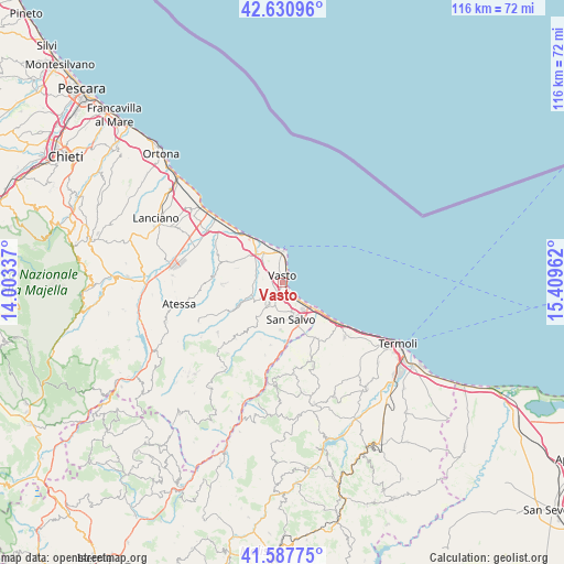
Vasto GPS coordinates[2]
42° 6' 41.4" North, 14° 42' 23.364" East
| Map corner | latitude | longitude |
|---|---|---|
| Upper-left | 42.63096°, | 14.00337° |
| Center: | 42.1115°, | 14.70649° |
| Lower-right: | 41.58775°, | 15.40962° |
| Map W x H: | 116×116 km | = 72.1×72.1mi |
| max Lat: | 47.04031° ⇑69.4% North |
| Vasto: | 42.1115° |
| min Lat: | ⇓30.6% South 35.50142° |
| min Long | Vasto | max Long |
| 6.69888° | 14.70649° | 18.48682° |
| W 84.5%⇐ | ⇒15.5% E |
Elevation
Elevation of Vasto is 149 m = 489 ft, and this is 157.7 m = 517 ft below average elevation for this country.
| Max E: |
2085 m = 6841 ft | 62% |
| Avg. | 306.7 m = 1006 ft | |
| Vasto | 149 m = 489 ft | |
Min E: |
-4 m = -13 ft | 38% |
See also: Italy elevation on elevation.city.
Geographical zone
Vasto is located in North temperate zone (between Tropic of Cancer and the Arctic Circle). Distance of this Northern Tropic circle is 2076.4 km =1290.2 mi to South.| Distance of | km | miles | from Vasto |
|---|---|---|---|
| North Pole | 5324.7 | 3308.6 | to North |
| Arctic Circle | 2718.8 | 1689.4 | to North |
| Tropic Cancer | 2076.4 | 1290.2 | to South |
| Equator | 4682.4 | 2909.5 | to South |


Nearby cities:
15 places around Vasto: (largest is in red/bold)
• Casalbordino-Miracoli
10 km =6.2 mi,  297°
297°
• Cupello
5.5 km =3.4 mi,  212°
212°
• Fresagrandinaria
15.2 km =9.4 mi,  193°
193°
• Furci
15.1 km =9.4 mi,  220°
220°
• Gissi
16.9 km =10.5 mi,  232°
232°
• Lentella
13.1 km =8.1 mi, 190°
• Marina di Vasto
2.6 km =1.6 mi,  139°
139°
• Monteodorisio
5.3 km =3.3 mi,  235°
235°
• Petacciato
17.1 km =10.6 mi,  132°
132°
• Pollutri
9.9 km =6.2 mi,  287°
287°
• Salvo Marina
6.7 km =4.2 mi, 132°
• San Salvo
7.8 km =4.8 mi,  163°
163°
• Scerni
10.9 km =6.8 mi,  265°
265°
• Torino di Sangro
16.1 km =10 mi, 303°
• Villalfonsina
12.5 km =7.8 mi, 295°
Sources, notices
• [Note1] Compared only with cities in Italy existing in our database
• [Src1] Map data: © OpenStreetMap contributors (CC-BY-SA)
• [Src2] Other city data from geonames.org with taken over terms of usage.
• [Src3] Geographical zone / Annual Mean Temperature by Robert A. Rohde @ Wikipedia
