Gissi geodata
Gissi (Abruzzo) is a seat of a third-order administrative division; located in Italy in Europe/Rome (GMT+2) time zone. With population of 1,881 people, there are 4352 cities with bigger population in this country. Compared to other cities in Italy, 70.1% of cities are located further ↑North; 83.1% of cities are located further ←West and 77.7% of cities have lower elevation than Gissi. Note1


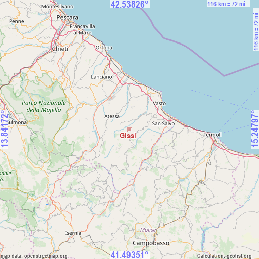
Gissi GPS coordinates[2]
42° 1' 4.908" North, 14° 32' 41.424" East
| Map corner | latitude | longitude |
|---|---|---|
| Upper-left | 42.53826°, | 13.84172° |
| Center: | 42.01803°, | 14.54484° |
| Lower-right: | 41.49351°, | 15.24797° |
| Map W x H: | 116.2×116.2 km | = 72.2×72.2mi |
| max Lat: | 47.04031° ⇑70.1% North |
| Gissi: | 42.01803° |
| min Lat: | ⇓29.9% South 35.50142° |
| min Long | Gissi | max Long |
| 6.69888° | 14.54484° | 18.48682° |
| W 83.1%⇐ | ⇒16.9% E |
Elevation
Elevation of Gissi is 489 m = 1604 ft, and this is 182.3 m = 598 ft above average elevation for this country.
| Max E: |
2085 m = 6841 ft | 22.3% |
| Gissi | 489 m 1604 ft | |
| Avg. | 306.7 m = 1006 ft | |
Min E: |
-4 m = -13 ft | 77.7% |
See also: Italy elevation on elevation.city.
Geographical zone
Gissi is located in North temperate zone (between Tropic of Cancer and the Arctic Circle). Distance of this Northern Tropic circle is 2066 km =1283.8 mi to South.| Distance of | km | miles | from Gissi |
|---|---|---|---|
| North Pole | 5335.1 | 3315.1 | to North |
| Arctic Circle | 2729.2 | 1695.8 | to North |
| Tropic Cancer | 2066 | 1283.8 | to South |
| Equator | 4672 | 2903 | to South |


Nearby cities:
15 places around Gissi: (largest is in red/bold)
• Atessa
9.7 km =6 mi,  306°
306°
• Carpineto Sinello
3.5 km =2.2 mi,  255°
255°
• Carunchio
11.3 km =7 mi,  187°
187°
• Casalanguida
4.6 km =2.9 mi,  298°
298°
• Dogliola
11.2 km =7 mi,  138°
138°
• Fresagrandinaria
10.6 km =6.6 mi,  114°
114°
• Furci
3.8 km =2.4 mi, 108°
• Guilmi
6 km =3.7 mi,  246°
246°
• Lentella
11.2 km =7 mi,  102°
102°
• Liscia
7 km =4.3 mi,  172°
172°
• Palmoli
9.2 km =5.7 mi,  160°
160°
• Roccaspinalveti-Santa Giusta
10.4 km =6.5 mi,  215°
215°
• San Buono
4.5 km =2.8 mi,  154°
154°
• Scerni
9.9 km =6.2 mi,  14°
14°
• Tornareccio
10.9 km =6.8 mi,  281°
281°
Sources, notices
• [Note1] Compared only with cities in Italy existing in our database
• [Src1] Map data: © OpenStreetMap contributors (CC-BY-SA)
• [Src2] Other city data from geonames.org with taken over terms of usage.
• [Src3] Geographical zone / Annual Mean Temperature by Robert A. Rohde @ Wikipedia
