Valdottavo geodata
Valdottavo (Tuscany) is a populated place; located in Italy in Europe/Rome (GMT+2) time zone. With population of 1,248 people, there are 5795 cities with bigger population in this country. Compared to other cities in Italy, 55.3% of cities are located further ↑North; 63% of cities are located further →East and 73.3% of cities have higher elevation than Valdottavo. Note1


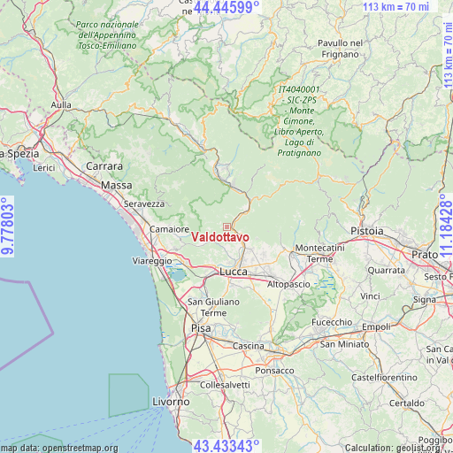
Valdottavo GPS coordinates[2]
43° 56' 30.732" North, 10° 28' 52.14" East
| Map corner | latitude | longitude |
|---|---|---|
| Upper-left | 44.44599°, | 9.77803° |
| Center: | 43.94187°, | 10.48115° |
| Lower-right: | 43.43343°, | 11.18428° |
| Map W x H: | 112.6×112.6 km | = 70×70mi |
| max Lat: | 47.04031° ⇑55.3% North |
| Valdottavo: | 43.94187° |
| min Lat: | ⇓44.7% South 35.50142° |
| min Long | Valdottavo | max Long |
| 6.69888° | 10.48115° | 18.48682° |
| W 37%⇐ | ⇒63% E |
Elevation
Elevation of Valdottavo is 82 m = 269 ft, and this is 224.7 m = 737 ft below average elevation for this country.
| Max E: |
2085 m = 6841 ft | 73.3% |
| Avg. | 306.7 m = 1006 ft | |
| Valdottavo | 82 m = 269 ft | |
Min E: |
-4 m = -13 ft | 26.7% |
See also: Italy elevation on elevation.city.
Geographical zone
Valdottavo is located in North temperate zone (between Tropic of Cancer and the Arctic Circle). Distance of this Northern Tropic circle is 2280 km =1416.7 mi to South.| Distance of | km | miles | from Valdottavo |
|---|---|---|---|
| North Pole | 5121.2 | 3182.2 | to North |
| Arctic Circle | 2515.3 | 1562.9 | to North |
| Tropic Cancer | 2280 | 1416.7 | to South |
| Equator | 4885.9 | 3036 | to South |


Nearby cities:
15 places around Valdottavo: (largest is in red/bold)
• Bagni di Lucca
9.1 km =5.7 mi,  39°
39°
• Borgo a Mozzano
6.6 km =4.1 mi,  50°
50°
• Corsagna
7.7 km =4.8 mi,  59°
59°
• Diecimo
3.2 km =2 mi, 41°
• Fabbriche di Vallico
7.5 km =4.7 mi,  325°
325°
• Filecchio
12.2 km =7.6 mi,  5°
5°
• Fornaci di Barga
11.9 km =7.4 mi,  356°
356°
• Lucca
11.1 km =6.9 mi,  170°
170°
• Matraia
8 km =5 mi,  114°
114°
• Nocchi
11.2 km =7 mi,  257°
257°
• Pescaglia
6 km =3.7 mi,  295°
295°
• Piano di Coreglia-Ghivizzano
10.6 km =6.6 mi,  15°
15°
• Ponte All'Ania
11.1 km =6.9 mi, 5°
• San Martino in Freddana-Monsagrati
5 km =3.1 mi,  223°
223°
• Villa Basilica
13.3 km =8.3 mi,  97°
97°
Sources, notices
• [Note1] Compared only with cities in Italy existing in our database
• [Src1] Map data: © OpenStreetMap contributors (CC-BY-SA)
• [Src2] Other city data from geonames.org with taken over terms of usage.
• [Src3] Geographical zone / Annual Mean Temperature by Robert A. Rohde @ Wikipedia
