Fornaci di Barga geodata
Fornaci di Barga (Tuscany) is a populated place; located in Italy in Europe/Rome (GMT+2) time zone. With population of 2,357 people, there are 3688 cities with bigger population in this country. Compared to other cities in Italy, 54.2% of cities are located further ↑North; 63.2% of cities are located further →East and 59.8% of cities have higher elevation than Fornaci di Barga. Note1


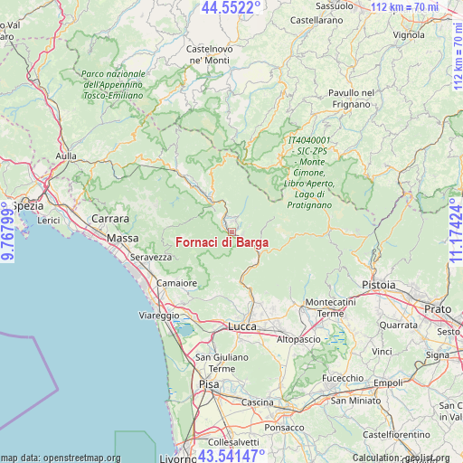
Fornaci di Barga GPS coordinates[2]
44° 2' 56.364" North, 10° 28' 15.996" East
| Map corner | latitude | longitude |
|---|---|---|
| Upper-left | 44.5522°, | 9.76799° |
| Center: | 44.04899°, | 10.47111° |
| Lower-right: | 43.54147°, | 11.17424° |
| Map W x H: | 112.4×112.4 km | = 69.8×69.8mi |
| max Lat: | 47.04031° ⇑54.2% North |
| Fornaci di Barga: | 44.04899° |
| min Lat: | ⇓45.8% South 35.50142° |
| min Long | Fornaci di Barg | max Long |
| 6.69888° | 10.47111° | 18.48682° |
| W 36.8%⇐ | ⇒63.2% E |
Elevation
Elevation of Fornaci di Barga is 165 m = 541 ft, and this is 141.7 m = 465 ft below average elevation for this country.
| Max E: |
2085 m = 6841 ft | 59.8% |
| Avg. | 306.7 m = 1006 ft | |
| Fornaci di Barga | 165 m = 541 ft | |
Min E: |
-4 m = -13 ft | 40.2% |
See also: Italy elevation on elevation.city.
Geographical zone
Fornaci di Barga is located in North temperate zone (between Tropic of Cancer and the Arctic Circle). Distance of this Northern Tropic circle is 2291.9 km =1424.1 mi to South.| Distance of | km | miles | from Fornaci di Barga |
|---|---|---|---|
| North Pole | 5109.3 | 3174.8 | to North |
| Arctic Circle | 2503.4 | 1555.5 | to North |
| Tropic Cancer | 2291.9 | 1424.1 | to South |
| Equator | 4897.8 | 3043.4 | to South |


Nearby cities:
15 places around Fornaci di Barga: (largest is in red/bold)
• Bagni di Lucca
8.2 km =5.1 mi,  126°
126°
• Barga
2.7 km =1.7 mi,  11°
11°
• Borgo a Mozzano
9.7 km =6 mi,  142°
142°
• Castelnuovo di Garfagnana
8.8 km =5.5 mi,  323°
323°
• Castelvecchio Pascoli
3.8 km =2.4 mi,  350°
350°
• Coreglia Antelminelli
4.5 km =2.8 mi,  70°
70°
• Diecimo
9.9 km =6.2 mi,  162°
162°
• Fabbriche di Vallico
6.7 km =4.2 mi,  211°
211°
• Filecchio
1.9 km =1.2 mi,  83°
83°
• Fosciandora
7.4 km =4.6 mi, 352°
• Gallicano
2.5 km =1.6 mi,  294°
294°
• Molazzana
5 km =3.1 mi,  300°
300°
• Piano di Coreglia-Ghivizzano
4 km =2.5 mi,  115°
115°
• Pieve Fosciana
10.3 km =6.4 mi,  331°
331°
• Ponte All'Ania
2 km =1.2 mi,  113°
113°
Sources, notices
• [Note1] Compared only with cities in Italy existing in our database
• [Src1] Map data: © OpenStreetMap contributors (CC-BY-SA)
• [Src2] Other city data from geonames.org with taken over terms of usage.
• [Src3] Geographical zone / Annual Mean Temperature by Robert A. Rohde @ Wikipedia
