Usseglio geodata
Usseglio (Piedmont) is a seat of a third-order administrative division; located in Italy in Europe/Rome (GMT+2) time zone. With population of 142 people, there are 11304 cities with bigger population in this country. Compared to other cities in Italy, 65.7% of cities are located further ↓South; 99.3% of cities are located further →East and 99% of cities have lower elevation than Usseglio. Note1


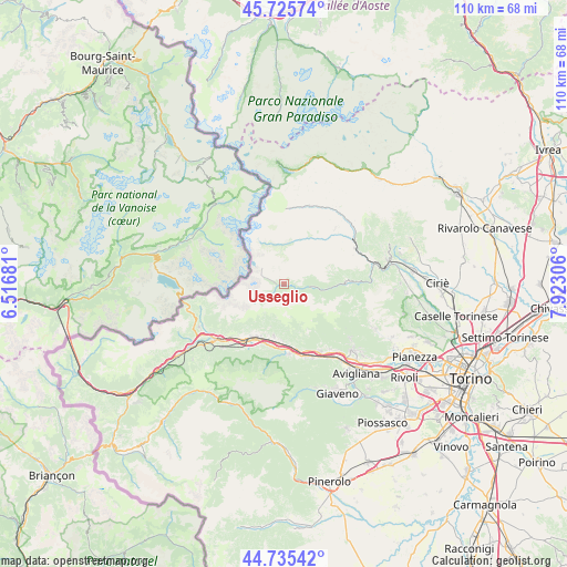
Usseglio GPS coordinates[2]
45° 13' 57.864" North, 7° 13' 11.748" East
| Map corner | latitude | longitude |
|---|---|---|
| Upper-left | 45.72574°, | 6.51681° |
| Center: | 45.23274°, | 7.21993° |
| Lower-right: | 44.73542°, | 7.92306° |
| Map W x H: | 110.1×110.1 km | = 68.4×68.4mi |
| max Lat: | 47.04031° ⇑34.3% North |
| Usseglio: | 45.23274° |
| min Lat: | ⇓65.7% South 35.50142° |
| min Long | Usseglio | max Long |
| 6.69888° | 7.21993° | 18.48682° |
| W 0.7%⇐ | ⇒99.3% E |
Elevation
Elevation of Usseglio is 1265 m = 4150 ft, and this is 958.3 m = 3144 ft above average elevation for this country.
| Max E: |
2085 m = 6841 ft | 1% |
| Usseglio | 1265 m 4150 ft | |
| Avg. | 306.7 m = 1006 ft | |
Min E: |
-4 m = -13 ft | 99% |
See also: Italy elevation on elevation.city.
Geographical zone
Usseglio is located in North temperate zone (between Tropic of Cancer and the Arctic Circle). Distance of this North polar circle is 2371.8 km =1473.8 mi to North.| Distance of | km | miles | from Usseglio |
|---|---|---|---|
| North Pole | 4977.7 | 3093 | to North |
| Arctic Circle | 2371.8 | 1473.8 | to North |
| Tropic Cancer | 2423.5 | 1505.9 | to South |
| Equator | 5029.4 | 3125.1 | to South |


Nearby cities:
15 places around Usseglio: (largest is in red/bold)
• Ala di Stura
11.2 km =7 mi,  35°
35°
• Balme
7.7 km =4.8 mi,  359°
359°
• Baratte
13.5 km =8.4 mi,  174°
174°
• Borgone Susa
12.2 km =7.6 mi, 173°
• Bruzolo
10.4 km =6.5 mi,  190°
190°
• Bussoleno
11.9 km =7.4 mi,  209°
209°
• Chianocco
10.2 km =6.3 mi,  202°
202°
• Condove
14.7 km =9.1 mi,  151°
151°
• Grangia
11 km =6.8 mi, 204°
• Lemie
5.7 km =3.5 mi,  94°
94°
• San Didero
10.8 km =6.7 mi,  182°
182°
• San Giorio
12.2 km =7.6 mi, 196°
• Sant'Antonino di Susa
14.5 km =9 mi,  163°
163°
• Villar Focchiardo
13.5 km =8.4 mi, 173°
• Viù
12 km =7.5 mi, 87°
Sources, notices
• [Note1] Compared only with cities in Italy existing in our database
• [Src1] Map data: © OpenStreetMap contributors (CC-BY-SA)
• [Src2] Other city data from geonames.org with taken over terms of usage.
• [Src3] Geographical zone / Annual Mean Temperature by Robert A. Rohde @ Wikipedia
