Urzulei geodata
Urzulei (Sardinia) is a seat of a third-order administrative division; located in Italy in Europe/Rome (GMT+2) time zone. With population of 1,272 people, there are 5721 cities with bigger population in this country. Compared to other cities in Italy, 87.2% of cities are located further ↑North; 73.1% of cities are located further →East and 78.8% of cities have lower elevation than Urzulei. Note1


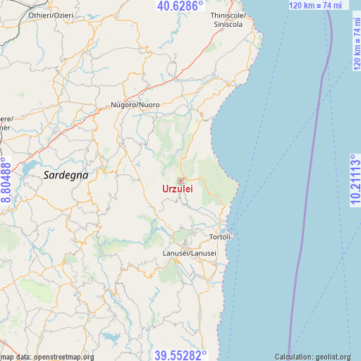
Urzulei GPS coordinates[2]
40° 5' 34.224" North, 9° 30' 28.8" East
| Map corner | latitude | longitude |
|---|---|---|
| Upper-left | 40.6286°, | 8.80488° |
| Center: | 40.09284°, | 9.508° |
| Lower-right: | 39.55282°, | 10.21113° |
| Map W x H: | 119.6×119.6 km | = 74.3×74.3mi |
| max Lat: | 47.04031° ⇑87.2% North |
| Urzulei: | 40.09284° |
| min Lat: | ⇓12.8% South 35.50142° |
| min Long | Urzulei | max Long |
| 6.69888° | 9.508° | 18.48682° |
| W 26.9%⇐ | ⇒73.1% E |
Elevation
Elevation of Urzulei is 504 m = 1654 ft, and this is 197.3 m = 647 ft above average elevation for this country.
| Max E: |
2085 m = 6841 ft | 21.2% |
| Urzulei | 504 m 1654 ft | |
| Avg. | 306.7 m = 1006 ft | |
Min E: |
-4 m = -13 ft | 78.8% |
See also: Italy elevation on elevation.city.
Geographical zone
Urzulei is located in North temperate zone (between Tropic of Cancer and the Arctic Circle). Distance of this Northern Tropic circle is 1852 km =1150.8 mi to South.| Distance of | km | miles | from Urzulei |
|---|---|---|---|
| North Pole | 5549.2 | 3448.1 | to North |
| Arctic Circle | 2943.3 | 1828.9 | to North |
| Tropic Cancer | 1852 | 1150.8 | to South |
| Equator | 4457.9 | 2770 | to South |


Nearby cities:
15 places around Urzulei: (largest is in red/bold)
• Arzana
19.6 km =12.2 mi,  175°
175°
• Baunei
14.9 km =9.3 mi,  117°
117°
• Elini
21.6 km =13.4 mi,  174°
174°
• Fonni
21.8 km =13.5 mi,  277°
277°
• Girasole
20.4 km =12.7 mi,  140°
140°
• Ilbono
22.5 km =14 mi, 171°
• Lotzorai
19.1 km =11.9 mi, 136°
• Oliena
22.3 km =13.9 mi,  336°
336°
• Orgosolo
18.1 km =11.2 mi,  313°
313°
• Santa Maria Navarrese
18.8 km =11.7 mi,  127°
127°
• Talana
5.8 km =3.6 mi,  190°
190°
• Tortolì
22.4 km =13.9 mi,  145°
145°
• Triei
12.9 km =8 mi, 119°
• Villagrande Strisaili
14.8 km =9.2 mi, 179°
• Villanova Strisaili
15.2 km =9.4 mi, 194°
Sources, notices
• [Note1] Compared only with cities in Italy existing in our database
• [Src1] Map data: © OpenStreetMap contributors (CC-BY-SA)
• [Src2] Other city data from geonames.org with taken over terms of usage.
• [Src3] Geographical zone / Annual Mean Temperature by Robert A. Rohde @ Wikipedia
