Treviglio geodata
Treviglio (Lombardy) is a seat of a third-order administrative division; located in Italy in Europe/Rome (GMT+2) time zone. With population of 24,937 people, there are 327 cities with bigger population in this country. Compared to other cities in Italy, 74.3% of cities are located further ↓South; 72.1% of cities are located further →East and 64.9% of cities have higher elevation than Treviglio. Note1


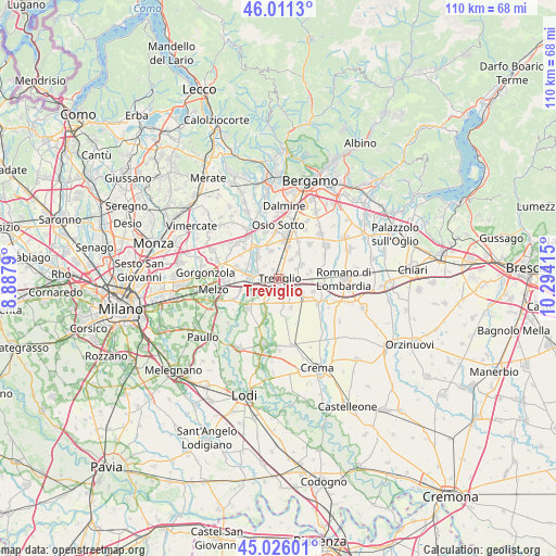
Treviglio GPS coordinates[2]
45° 31' 14.916" North, 9° 35' 27.672" East
| Map corner | latitude | longitude |
|---|---|---|
| Upper-left | 46.0113°, | 8.8879° |
| Center: | 45.52081°, | 9.59102° |
| Lower-right: | 45.02601°, | 10.29415° |
| Map W x H: | 109.6×109.6 km | = 68.1×68.1mi |
| max Lat: | 47.04031° ⇑25.7% North |
| Treviglio: | 45.52081° |
| min Lat: | ⇓74.3% South 35.50142° |
| min Long | Treviglio | max Long |
| 6.69888° | 9.59102° | 18.48682° |
| W 27.9%⇐ | ⇒72.1% E |
Elevation
Elevation of Treviglio is 128 m = 420 ft, and this is 178.7 m = 586 ft below average elevation for this country.
| Max E: |
2085 m = 6841 ft | 64.9% |
| Avg. | 306.7 m = 1006 ft | |
| Treviglio | 128 m = 420 ft | |
Min E: |
-4 m = -13 ft | 35.1% |
See also: Italy elevation on elevation.city.
Geographical zone
Treviglio is located in North temperate zone (between Tropic of Cancer and the Arctic Circle). Distance of this North polar circle is 2339.7 km =1453.8 mi to North.| Distance of | km | miles | from Treviglio |
|---|---|---|---|
| North Pole | 4945.6 | 3073.1 | to North |
| Arctic Circle | 2339.7 | 1453.8 | to North |
| Tropic Cancer | 2455.5 | 1525.8 | to South |
| Equator | 5061.4 | 3145 | to South |


Nearby cities:
15 places around Treviglio: (largest is in red/bold)
• Arzago d'Adda
4.9 km =3 mi,  205°
205°
• Badalasco
3.7 km =2.3 mi,  310°
310°
• Brignano Gera d'Adda
4.8 km =3 mi,  58°
58°
• Calvenzano
2.8 km =1.7 mi,  166°
166°
• Caravaggio
4.8 km =3 mi,  124°
124°
• Cascine San Pietro
4.9 km =3 mi,  250°
250°
• Casirate d'Adda
3.3 km =2.1 mi, 210°
• Cassano d'Adda
5.9 km =3.7 mi,  275°
275°
• Castel Rozzone
4.2 km =2.6 mi,  32°
32°
• Fara Gera d'Adda
5.8 km =3.6 mi, 313°
• Geromina
2.1 km =1.3 mi,  325°
325°
• Lurano
6.3 km =3.9 mi,  37°
37°
• Misano di Gera d'Adda
6.2 km =3.9 mi,  157°
157°
• Pontirolo Nuovo
5.6 km =3.5 mi,  342°
342°
• Vidalengo
3.9 km =2.4 mi,  87°
87°
Sources, notices
• [Note1] Compared only with cities in Italy existing in our database
• [Src1] Map data: © OpenStreetMap contributors (CC-BY-SA)
• [Src2] Other city data from geonames.org with taken over terms of usage.
• [Src3] Geographical zone / Annual Mean Temperature by Robert A. Rohde @ Wikipedia
