Lurano geodata
Lurano (Lombardy) is a seat of a third-order administrative division; located in Italy in Europe/Rome (GMT+2) time zone. With population of 2,486 people, there are 3544 cities with bigger population in this country. Compared to other cities in Italy, 75.7% of cities are located further ↓South; 71.4% of cities are located further →East and 62.6% of cities have higher elevation than Lurano. Note1


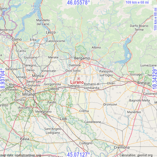
Lurano GPS coordinates[2]
45° 33' 56.448" North, 9° 38' 24.576" East
| Map corner | latitude | longitude |
|---|---|---|
| Upper-left | 46.05578°, | 8.93704° |
| Center: | 45.56568°, | 9.64016° |
| Lower-right: | 45.07127°, | 10.34329° |
| Map W x H: | 109.5×109.5 km | = 68×68mi |
| max Lat: | 47.04031° ⇑24.3% North |
| Lurano: | 45.56568° |
| min Lat: | ⇓75.7% South 35.50142° |
| min Long | Lurano | max Long |
| 6.69888° | 9.64016° | 18.48682° |
| W 28.6%⇐ | ⇒71.4% E |
Elevation
Elevation of Lurano is 144 m = 472 ft, and this is 162.7 m = 534 ft below average elevation for this country.
| Max E: |
2085 m = 6841 ft | 62.6% |
| Avg. | 306.7 m = 1006 ft | |
| Lurano | 144 m = 472 ft | |
Min E: |
-4 m = -13 ft | 37.4% |
See also: Italy elevation on elevation.city.
Geographical zone
Lurano is located in North temperate zone (between Tropic of Cancer and the Arctic Circle). Distance of this North polar circle is 2334.7 km =1450.7 mi to North.| Distance of | km | miles | from Lurano |
|---|---|---|---|
| North Pole | 4940.6 | 3069.9 | to North |
| Arctic Circle | 2334.7 | 1450.7 | to North |
| Tropic Cancer | 2460.5 | 1528.9 | to South |
| Equator | 5066.4 | 3148.1 | to South |


Nearby cities:
15 places around Lurano: (largest is in red/bold)
• Arcene
2.4 km =1.5 mi,  302°
302°
• Boltiere
6.2 km =3.9 mi,  309°
309°
• Brignano Gera d'Adda
2.5 km =1.6 mi,  172°
172°
• Castel Rozzone
2.2 km =1.4 mi,  226°
226°
• Ciserano
3.9 km =2.4 mi, 309°
• Cologno al Serio
5.5 km =3.4 mi,  77°
77°
• Geromina
6 km =3.7 mi,  237°
237°
• Pagazzano
4.2 km =2.6 mi,  145°
145°
• Pognano
2.3 km =1.4 mi,  359°
359°
• Pontirolo Nuovo
5.5 km =3.4 mi,  274°
274°
• Spirano
2.8 km =1.7 mi,  51°
51°
• Urgnano
5.7 km =3.5 mi, 48°
• Verdellino
4.7 km =2.9 mi,  327°
327°
• Verdello
4.3 km =2.7 mi,  347°
347°
• Vidalengo
4.8 km =3 mi,  178°
178°
Sources, notices
• [Note1] Compared only with cities in Italy existing in our database
• [Src1] Map data: © OpenStreetMap contributors (CC-BY-SA)
• [Src2] Other city data from geonames.org with taken over terms of usage.
• [Src3] Geographical zone / Annual Mean Temperature by Robert A. Rohde @ Wikipedia
