Trevico geodata
Trevico (Campania) is a seat of a third-order administrative division; located in Italy in Europe/Rome (GMT+2) time zone. With population of 356 people, there are 10456 cities with bigger population in this country. Compared to other cities in Italy, 78% of cities are located further ↑North; 89.1% of cities are located further ←West and 97.7% of cities have lower elevation than Trevico. Note1


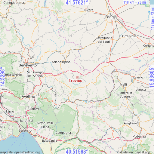
Trevico GPS coordinates[2]
41° 2' 53.088" North, 15° 13' 58.512" East
| Map corner | latitude | longitude |
|---|---|---|
| Upper-left | 41.57621°, | 14.5298° |
| Center: | 41.04808°, | 15.23292° |
| Lower-right: | 40.51568°, | 15.93605° |
| Map W x H: | 117.9×117.9 km | = 73.3×73.3mi |
| max Lat: | 47.04031° ⇑78% North |
| Trevico: | 41.04808° |
| min Lat: | ⇓22% South 35.50142° |
| min Long | Trevico | max Long |
| 6.69888° | 15.23292° | 18.48682° |
| W 89.1%⇐ | ⇒10.9% E |
Elevation
Elevation of Trevico is 1061 m = 3481 ft, and this is 754.3 m = 2475 ft above average elevation for this country.
| Max E: |
2085 m = 6841 ft | 2.3% |
| Trevico | 1061 m 3481 ft | |
| Avg. | 306.7 m = 1006 ft | |
Min E: |
-4 m = -13 ft | 97.7% |
See also: Italy elevation on elevation.city.
Geographical zone
Trevico is located in North temperate zone (between Tropic of Cancer and the Arctic Circle). Distance of this Northern Tropic circle is 1958.2 km =1216.8 mi to South.| Distance of | km | miles | from Trevico |
|---|---|---|---|
| North Pole | 5442.9 | 3382.1 | to North |
| Arctic Circle | 2837.1 | 1762.9 | to North |
| Tropic Cancer | 1958.2 | 1216.8 | to South |
| Equator | 4564.1 | 2836 | to South |


Nearby cities:
15 places around Trevico: (largest is in red/bold)
• Anzano di Puglia
9.3 km =5.8 mi,  28°
28°
• Bisaccia Nuova
11.1 km =6.9 mi,  112°
112°
• Carife
3 km =1.9 mi,  218°
218°
• Castel Baronia
3.7 km =2.3 mi,  270°
270°
• Flumeri
7.6 km =4.7 mi,  294°
294°
• Guardia Lombardi
10.9 km =6.8 mi,  190°
190°
• Pagliara
10.6 km =6.6 mi,  237°
237°
• San Nicola Baronia
3 km =1.9 mi, 291°
• San Sossio Baronia
3.7 km =2.3 mi,  313°
313°
• Scampitella
7.5 km =4.7 mi,  48°
48°
• Sturno
10.5 km =6.5 mi,  254°
254°
• Vallata
2 km =1.2 mi,  116°
116°
• Vallesaccarda
2.3 km =1.4 mi,  43°
43°
• Villanova del Battista
10.1 km =6.3 mi,  321°
321°
• Zungoli
9.2 km =5.7 mi,  343°
343°
Sources, notices
• [Note1] Compared only with cities in Italy existing in our database
• [Src1] Map data: © OpenStreetMap contributors (CC-BY-SA)
• [Src2] Other city data from geonames.org with taken over terms of usage.
• [Src3] Geographical zone / Annual Mean Temperature by Robert A. Rohde @ Wikipedia
