Carife geodata
Carife (Campania) is a seat of a third-order administrative division; located in Italy in Europe/Rome (GMT+2) time zone. With population of 1,214 people, there are 5916 cities with bigger population in this country. Compared to other cities in Italy, 78.4% of cities are located further ↑North; 88.9% of cities are located further ←West and 89.5% of cities have lower elevation than Carife. Note1


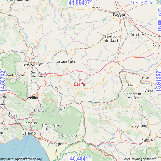
Carife GPS coordinates[2]
41° 1' 36.012" North, 15° 12' 37.584" East
| Map corner | latitude | longitude |
|---|---|---|
| Upper-left | 41.55497°, | 14.50732° |
| Center: | 41.02667°, | 15.21044° |
| Lower-right: | 40.4941°, | 15.91357° |
| Map W x H: | 118×118 km | = 73.3×73.3mi |
| max Lat: | 47.04031° ⇑78.4% North |
| Carife: | 41.02667° |
| min Lat: | ⇓21.6% South 35.50142° |
| min Long | Carife | max Long |
| 6.69888° | 15.21044° | 18.48682° |
| W 88.9%⇐ | ⇒11.1% E |
Elevation
Elevation of Carife is 708 m = 2323 ft, and this is 401.3 m = 1317 ft above average elevation for this country.
| Max E: |
2085 m = 6841 ft | 10.5% |
| Carife | 708 m 2323 ft | |
| Avg. | 306.7 m = 1006 ft | |
Min E: |
-4 m = -13 ft | 89.5% |
See also: Italy elevation on elevation.city.
Geographical zone
Carife is located in North temperate zone (between Tropic of Cancer and the Arctic Circle). Distance of this Northern Tropic circle is 1955.8 km =1215.3 mi to South.| Distance of | km | miles | from Carife |
|---|---|---|---|
| North Pole | 5445.3 | 3383.6 | to North |
| Arctic Circle | 2839.4 | 1764.3 | to North |
| Tropic Cancer | 1955.8 | 1215.3 | to South |
| Equator | 4561.7 | 2834.5 | to South |


Nearby cities:
15 places around Carife: (largest is in red/bold)
• Castel Baronia
3 km =1.9 mi,  323°
323°
• Flumeri
7.4 km =4.6 mi, 317°
• Frigento
9.4 km =5.8 mi,  259°
259°
• Guardia Lombardi
8.3 km =5.2 mi,  180°
180°
• Morra de Sanctis
11.2 km =7 mi,  165°
165°
• Pagliara
7.8 km =4.8 mi,  244°
244°
• Rocca San Felice
9.3 km =5.8 mi,  203°
203°
• San Nicola Baronia
3.6 km =2.2 mi,  346°
346°
• San Sossio Baronia
5 km =3.1 mi, 351°
• Sant'Angelo dei Lombardi
11.2 km =7 mi, 195°
• Scampitella
10.5 km =6.5 mi,  45°
45°
• Sturno
8.2 km =5.1 mi,  266°
266°
• Trevico
3 km =1.9 mi,  38°
38°
• Vallata
3.9 km =2.4 mi,  67°
67°
• Vallesaccarda
5.3 km =3.3 mi, 40°
Sources, notices
• [Note1] Compared only with cities in Italy existing in our database
• [Src1] Map data: © OpenStreetMap contributors (CC-BY-SA)
• [Src2] Other city data from geonames.org with taken over terms of usage.
• [Src3] Geographical zone / Annual Mean Temperature by Robert A. Rohde @ Wikipedia
