Tregnago geodata
Tregnago (Veneto) is a seat of a third-order administrative division; located in Italy in Europe/Rome (GMT+2) time zone. With population of 3,601 people, there are 2620 cities with bigger population in this country. Compared to other cities in Italy, 74.1% of cities are located further ↓South; 54.9% of cities are located further →East and 61.9% of cities have lower elevation than Tregnago. Note1


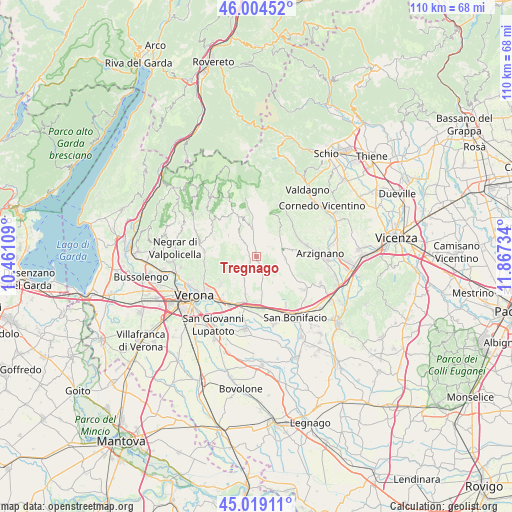
Tregnago GPS coordinates[2]
45° 30' 50.292" North, 11° 9' 51.156" East
| Map corner | latitude | longitude |
|---|---|---|
| Upper-left | 46.00452°, | 10.46109° |
| Center: | 45.51397°, | 11.16421° |
| Lower-right: | 45.01911°, | 11.86734° |
| Map W x H: | 109.6×109.6 km | = 68.1×68.1mi |
| max Lat: | 47.04031° ⇑25.9% North |
| Tregnago: | 45.51397° |
| min Lat: | ⇓74.1% South 35.50142° |
| min Long | Tregnago | max Long |
| 6.69888° | 11.16421° | 18.48682° |
| W 45.1%⇐ | ⇒54.9% E |
Elevation
Elevation of Tregnago is 314 m = 1030 ft, and this is 7.3 m = 24 ft above average elevation for this country.
| Max E: |
2085 m = 6841 ft | 38.1% |
| Tregnago | 314 m 1030 ft | |
| Avg. | 306.7 m = 1006 ft | |
Min E: |
-4 m = -13 ft | 61.9% |
See also: Italy elevation on elevation.city.
Geographical zone
Tregnago is located in North temperate zone (between Tropic of Cancer and the Arctic Circle). Distance of this North polar circle is 2340.5 km =1454.3 mi to North.| Distance of | km | miles | from Tregnago |
|---|---|---|---|
| North Pole | 4946.4 | 3073.5 | to North |
| Arctic Circle | 2340.5 | 1454.3 | to North |
| Tropic Cancer | 2454.8 | 1525.3 | to South |
| Equator | 5060.7 | 3144.6 | to South |


Nearby cities:
15 places around Tregnago: (largest is in red/bold)
• Badia Calavena
5.7 km =3.5 mi,  350°
350°
• Cazzano di Tramigna
5.5 km =3.4 mi,  146°
146°
• Cellore
3.3 km =2.1 mi,  160°
160°
• Cogollo
3.6 km =2.2 mi, 350°
• Illasi
5.4 km =3.4 mi,  165°
165°
• Lavagno
8.7 km =5.4 mi,  195°
195°
• Marcellise
7.4 km =4.6 mi,  217°
217°
• Mezzane di Sotto
4.6 km =2.9 mi, 218°
• Montecchia di Crosara
7.9 km =4.9 mi,  116°
116°
• San Briccio
7.5 km =4.7 mi,  208°
208°
• San Giovanni Ilarione
5.7 km =3.5 mi,  84°
84°
• San Mauro di Saline
6.9 km =4.3 mi,  324°
324°
• San Pietro
8.4 km =5.2 mi, 198°
• San Rocco
7.4 km =4.6 mi,  305°
305°
• Vestenanova
8.4 km =5.2 mi,  36°
36°
Sources, notices
• [Note1] Compared only with cities in Italy existing in our database
• [Src1] Map data: © OpenStreetMap contributors (CC-BY-SA)
• [Src2] Other city data from geonames.org with taken over terms of usage.
• [Src3] Geographical zone / Annual Mean Temperature by Robert A. Rohde @ Wikipedia
