Traversetolo geodata
Traversetolo (Emilia-Romagna) is a seat of a third-order administrative division; located in Italy in Europe/Rome (GMT+2) time zone. With population of 5,406 people, there are 1810 cities with bigger population in this country. Compared to other cities in Italy, 53.2% of cities are located further ↓South; 64.1% of cities are located further →East and 58.4% of cities have higher elevation than Traversetolo. Note1
Administrative division(s):
- Level 1: Emilia-Romagna
- Level 2: Provincia di Parma
- Level 3: Traversetolo


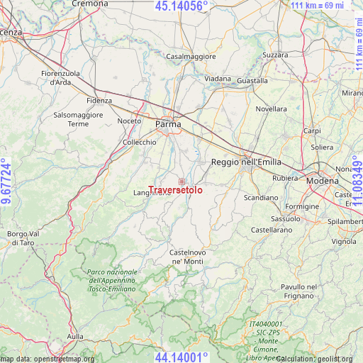
Traversetolo GPS coordinates[2]
44° 38' 32.784" North, 10° 22' 49.296" East
| Map corner | latitude | longitude |
|---|---|---|
| Upper-left | 45.14056°, | 9.67724° |
| Center: | 44.64244°, | 10.38036° |
| Lower-right: | 44.14001°, | 11.08349° |
| Map W x H: | 111.3×111.2 km | = 69.2×69.1mi |
| max Lat: | 47.04031° ⇑46.8% North |
| Traversetolo: | 44.64244° |
| min Lat: | ⇓53.2% South 35.50142° |
| min Long | Traversetolo | max Long |
| 6.69888° | 10.38036° | 18.48682° |
| W 35.9%⇐ | ⇒64.1% E |
Elevation
Elevation of Traversetolo is 176 m = 577 ft, and this is 130.7 m = 429 ft below average elevation for this country.
| Max E: |
2085 m = 6841 ft | 58.4% |
| Avg. | 306.7 m = 1006 ft | |
| Traversetolo | 176 m = 577 ft | |
Min E: |
-4 m = -13 ft | 41.6% |
See also: Italy elevation on elevation.city.
Geographical zone
Traversetolo is located in North temperate zone (between Tropic of Cancer and the Arctic Circle). Distance of this Northern Tropic circle is 2357.9 km =1465.1 mi to South.| Distance of | km | miles | from Traversetolo |
|---|---|---|---|
| North Pole | 5043.3 | 3133.8 | to North |
| Arctic Circle | 2437.4 | 1514.5 | to North |
| Tropic Cancer | 2357.9 | 1465.1 | to South |
| Equator | 4963.8 | 3084.4 | to South |


Nearby cities:
15 places around Traversetolo: (largest is in red/bold)
• Barcaccia
4.5 km =2.8 mi,  58°
58°
• Basilicagoiano
7.3 km =4.5 mi,  15°
15°
• Basilicanova
6.6 km =4.1 mi,  340°
340°
• Bibbiano
7.7 km =4.8 mi,  72°
72°
• Ciano d'Enza
5.3 km =3.3 mi,  153°
153°
• Lesignano de'Bagni
6.3 km =3.9 mi,  271°
271°
• Mamiano
4.7 km =2.9 mi,  319°
319°
• Montecchio Emilia
8.5 km =5.3 mi,  41°
41°
• Montechiarugolo
6.4 km =4 mi,  30°
30°
• Neviano degli Arduini
8.3 km =5.2 mi,  217°
217°
• Pannocchia
6.8 km =4.2 mi,  304°
304°
• Quattro Castella
7.5 km =4.7 mi,  96°
96°
• San Polo d'Enza
4.1 km =2.5 mi,  115°
115°
• Santa Maria del Piano
5.3 km =3.3 mi,  284°
284°
• Vignale
1.6 km =1 mi,  110°
110°
Sources, notices
• [Note1] Compared only with cities in Italy existing in our database
• [Src1] Map data: © OpenStreetMap contributors (CC-BY-SA)
• [Src2] Other city data from geonames.org with taken over terms of usage.
• [Src3] Geographical zone / Annual Mean Temperature by Robert A. Rohde @ Wikipedia
