Barcaccia geodata
Barcaccia (Emilia-Romagna) is a populated place; located in Italy in Europe/Rome (GMT+2) time zone. With population of 657 people, there are 8585 cities with bigger population in this country. Compared to other cities in Italy, 53.6% of cities are located further ↓South; 63.6% of cities are located further →East and 65.1% of cities have higher elevation than Barcaccia. Note1
Administrative division(s):
- Level 1: Emilia-Romagna
- Level 2: Provincia di Reggio Emilia
- Level 3: San Polo d'Enza


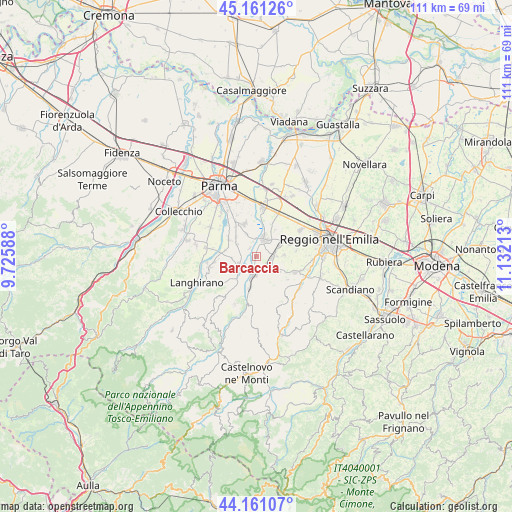
Barcaccia GPS coordinates[2]
44° 39' 47.952" North, 10° 25' 44.4" East
| Map corner | latitude | longitude |
|---|---|---|
| Upper-left | 45.16126°, | 9.72588° |
| Center: | 44.66332°, | 10.429° |
| Lower-right: | 44.16107°, | 11.13213° |
| Map W x H: | 111.2×111.2 km | = 69.1×69.1mi |
| max Lat: | 47.04031° ⇑46.4% North |
| Barcaccia: | 44.66332° |
| min Lat: | ⇓53.6% South 35.50142° |
| min Long | Barcaccia | max Long |
| 6.69888° | 10.429° | 18.48682° |
| W 36.4%⇐ | ⇒63.6% E |
Elevation
Elevation of Barcaccia is 127 m = 417 ft, and this is 179.7 m = 590 ft below average elevation for this country.
| Max E: |
2085 m = 6841 ft | 65.1% |
| Avg. | 306.7 m = 1006 ft | |
| Barcaccia | 127 m = 417 ft | |
Min E: |
-4 m = -13 ft | 34.9% |
See also: Italy elevation on elevation.city.
Geographical zone
Barcaccia is located in North temperate zone (between Tropic of Cancer and the Arctic Circle). Distance of this Northern Tropic circle is 2360.2 km =1466.6 mi to South.| Distance of | km | miles | from Barcaccia |
|---|---|---|---|
| North Pole | 5041 | 3132.3 | to North |
| Arctic Circle | 2435.1 | 1513.1 | to North |
| Tropic Cancer | 2360.2 | 1466.6 | to South |
| Equator | 4966.1 | 3085.8 | to South |


Nearby cities:
15 places around Barcaccia: (largest is in red/bold)
• Barco
6 km =3.7 mi,  62°
62°
• Basilicagoiano
5.1 km =3.2 mi,  337°
337°
• Basilicanova
7.2 km =4.5 mi,  302°
302°
• Bibbiano
3.6 km =2.2 mi,  90°
90°
• Ciano d'Enza
7.2 km =4.5 mi,  191°
191°
• Ghiardo
6 km =3.7 mi, 86°
• Mamiano
7 km =4.3 mi,  279°
279°
• Montecchio Emilia
4.4 km =2.7 mi,  24°
24°
• Montechiarugolo
3.3 km =2.1 mi,  349°
349°
• Monticelli Terme
7.8 km =4.8 mi, 339°
• Quattro Castella
4.8 km =3 mi,  131°
131°
• Roncolo
6.3 km =3.9 mi,  121°
121°
• San Polo d'Enza
4.1 km =2.5 mi,  182°
182°
• Traversetolo
4.5 km =2.8 mi,  238°
238°
• Vignale
3.7 km =2.3 mi,  219°
219°
Sources, notices
• [Note1] Compared only with cities in Italy existing in our database
• [Src1] Map data: © OpenStreetMap contributors (CC-BY-SA)
• [Src2] Other city data from geonames.org with taken over terms of usage.
• [Src3] Geographical zone / Annual Mean Temperature by Robert A. Rohde @ Wikipedia
