Tradate geodata
Tradate (Lombardy) is a seat of a third-order administrative division; located in Italy in Europe/Rome (GMT+2) time zone. With population of 17,154 people, there are 519 cities with bigger population in this country. Compared to other cities in Italy, 81.6% of cities are located further ↓South; 82.6% of cities are located further →East and 60% of cities have lower elevation than Tradate. Note1


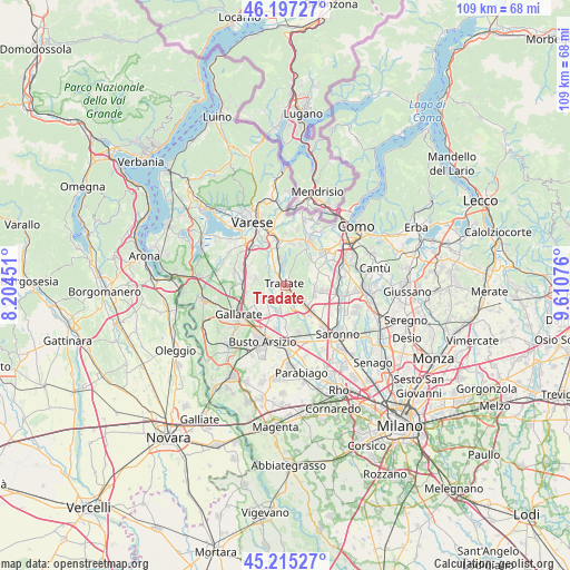
Tradate GPS coordinates[2]
45° 42' 30.348" North, 8° 54' 27.468" East
| Map corner | latitude | longitude |
|---|---|---|
| Upper-left | 46.19727°, | 8.20451° |
| Center: | 45.70843°, | 8.90763° |
| Lower-right: | 45.21527°, | 9.61076° |
| Map W x H: | 109.2×109.2 km | = 67.9×67.9mi |
| max Lat: | 47.04031° ⇑18.4% North |
| Tradate: | 45.70843° |
| min Lat: | ⇓81.6% South 35.50142° |
| min Long | Tradate | max Long |
| 6.69888° | 8.90763° | 18.48682° |
| W 17.4%⇐ | ⇒82.6% E |
Elevation
Elevation of Tradate is 299 m = 981 ft, and this is 7.7 m = 25 ft below average elevation for this country.
| Max E: |
2085 m = 6841 ft | 40% |
| Avg. | 306.7 m = 1006 ft | |
| Tradate | 299 m = 981 ft | |
Min E: |
-4 m = -13 ft | 60% |
See also: Italy elevation on elevation.city.
Geographical zone
Tradate is located in North temperate zone (between Tropic of Cancer and the Arctic Circle). Distance of this North polar circle is 2318.9 km =1440.9 mi to North.| Distance of | km | miles | from Tradate |
|---|---|---|---|
| North Pole | 4924.8 | 3060.1 | to North |
| Arctic Circle | 2318.9 | 1440.9 | to North |
| Tropic Cancer | 2476.4 | 1538.8 | to South |
| Equator | 5082.3 | 3158 | to South |


Nearby cities:
15 places around Tradate: (largest is in red/bold)
• Bolladello-Peveranza
5.4 km =3.4 mi,  243°
243°
• Cairate
3.9 km =2.4 mi,  232°
232°
• Carbonate
3.5 km =2.2 mi,  137°
137°
• Castelseprio
3.6 km =2.2 mi,  279°
279°
• Castiglione Olona
5.6 km =3.5 mi,  331°
331°
• Fagnano Olona-Bergoro
5.7 km =3.5 mi,  220°
220°
• Gorla Maggiore
5 km =3.1 mi,  190°
190°
• Gornate Olona
5.2 km =3.2 mi,  314°
314°
• Locate Varesino
2.7 km =1.7 mi, 140°
• Lonate Ceppino
2.2 km =1.4 mi,  270°
270°
• Lurago Marinone
5.9 km =3.7 mi,  93°
93°
• Mozzate
5.3 km =3.3 mi,  134°
134°
• Rovate
4.8 km =3 mi, 272°
• Venegono Inferiore
3.2 km =2 mi,  342°
342°
• Venegono Superiore
5 km =3.1 mi,  350°
350°
Sources, notices
• [Note1] Compared only with cities in Italy existing in our database
• [Src1] Map data: © OpenStreetMap contributors (CC-BY-SA)
• [Src2] Other city data from geonames.org with taken over terms of usage.
• [Src3] Geographical zone / Annual Mean Temperature by Robert A. Rohde @ Wikipedia
