Bolladello-Peveranza geodata
Bolladello-Peveranza (Lombardy) is a populated place; located in Italy in Europe/Rome (GMT+2) time zone. With population of 3,885 people, there are 2464 cities with bigger population in this country. Compared to other cities in Italy, 80.5% of cities are located further ↓South; 83.6% of cities are located further →East and 57.3% of cities have lower elevation than Bolladello-Peveranza. Note1
Current local time in Bolladello-Peveranza:
09:36 PM, WednesdayDifference from your time zone: hours


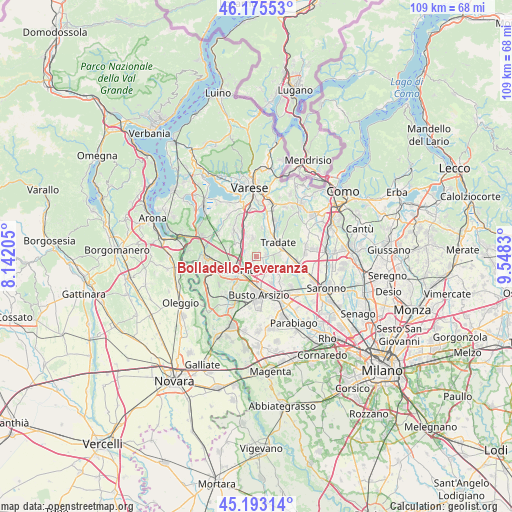
Bolladello-Peveranza GPS coordinates[2]
45° 41' 11.364" North, 8° 50' 42.612" East
| Map corner | latitude | longitude |
|---|---|---|
| Upper-left | 46.17553°, | 8.14205° |
| Center: | 45.68649°, | 8.84517° |
| Lower-right: | 45.19314°, | 9.5483° |
| Map W x H: | 109.2×109.2 km | = 67.9×67.9mi |
| max Lat: | 47.04031° ⇑19.5% North |
| Bolladello-Peveranza: | 45.68649° |
| min Lat: | ⇓80.5% South 35.50142° |
| min Long | Bolladello-Peve | max Long |
| 6.69888° | 8.84517° | 18.48682° |
| W 16.4%⇐ | ⇒83.6% E |
Elevation
Elevation of Bolladello-Peveranza is 281 m = 922 ft, and this is 25.7 m = 84 ft below average elevation for this country.
| Max E: |
2085 m = 6841 ft | 42.7% |
| Avg. | 306.7 m = 1006 ft | |
| Bolladello-Peveranza | 281 m = 922 ft | |
Min E: |
-4 m = -13 ft | 57.3% |
See also: Italy elevation on elevation.city.
Geographical zone
Bolladello-Peveranza is located in North temperate zone (between Tropic of Cancer and the Arctic Circle). Distance of this North polar circle is 2321.3 km =1442.4 mi to North.| Distance of | km | miles | from Bolladello-Peveranza |
|---|---|---|---|
| North Pole | 4927.2 | 3061.6 | to North |
| Arctic Circle | 2321.3 | 1442.4 | to North |
| Tropic Cancer | 2473.9 | 1537.2 | to South |
| Equator | 5079.9 | 3156.5 | to South |


Nearby cities:
15 places around Bolladello-Peveranza: (largest is in red/bold)
• Cairate
1.8 km =1.1 mi,  86°
86°
• Carnago
4 km =2.5 mi,  347°
347°
• Cassano Magnago
2.1 km =1.3 mi,  221°
221°
• Castelseprio
3.3 km =2.1 mi,  22°
22°
• Cavaria Con Premezzo
3.3 km =2.1 mi,  281°
281°
• Fagnano Olona-Bergoro
2.2 km =1.4 mi,  148°
148°
• Gallarate
5.1 km =3.2 mi,  234°
234°
• Gorla Maggiore
4.6 km =2.9 mi,  122°
122°
• Jerago Con Orago
4.3 km =2.7 mi,  297°
297°
• Lonate Ceppino
3.6 km =2.2 mi,  47°
47°
• Monte
3.6 km =2.2 mi,  330°
330°
• Oggiona-Santo Stefano
3 km =1.9 mi,  311°
311°
• Rovate
2.7 km =1.7 mi,  0°
0°
• Solbiate Arno
4.4 km =2.7 mi, 326°
• Solbiate Olona
4.9 km =3 mi,  144°
144°
Sources, notices
• [Note1] Compared only with cities in Italy existing in our database
• [Src1] Map data: © OpenStreetMap contributors (CC-BY-SA)
• [Src2] Other city data from geonames.org with taken over terms of usage.
• [Src3] Geographical zone / Annual Mean Temperature by Robert A. Rohde @ Wikipedia
