Tolve geodata
Tolve (Basilicate) is a seat of a third-order administrative division; located in Italy in Europe/Rome (GMT+2) time zone. With population of 3,361 people, there are 2787 cities with bigger population in this country. Compared to other cities in Italy, 82.5% of cities are located further ↑North; 92.9% of cities are located further ←West and 78.8% of cities have lower elevation than Tolve. Note1


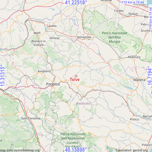
Tolve GPS coordinates[2]
40° 41' 39.192" North, 16° 0' 58.572" East
| Map corner | latitude | longitude |
|---|---|---|
| Upper-left | 41.22519°, | 15.31315° |
| Center: | 40.69422°, | 16.01627° |
| Lower-right: | 40.15898°, | 16.7194° |
| Map W x H: | 118.6×118.6 km | = 73.7×73.7mi |
| max Lat: | 47.04031° ⇑82.5% North |
| Tolve: | 40.69422° |
| min Lat: | ⇓17.5% South 35.50142° |
| min Long | Tolve | max Long |
| 6.69888° | 16.01627° | 18.48682° |
| W 92.9%⇐ | ⇒7.1% E |
Elevation
Elevation of Tolve is 504 m = 1654 ft, and this is 197.3 m = 647 ft above average elevation for this country.
| Max E: |
2085 m = 6841 ft | 21.2% |
| Tolve | 504 m 1654 ft | |
| Avg. | 306.7 m = 1006 ft | |
Min E: |
-4 m = -13 ft | 78.8% |
See also: Italy elevation on elevation.city.
Geographical zone
Tolve is located in North temperate zone (between Tropic of Cancer and the Arctic Circle). Distance of this Northern Tropic circle is 1918.9 km =1192.3 mi to South.| Distance of | km | miles | from Tolve |
|---|---|---|---|
| North Pole | 5482.3 | 3406.5 | to North |
| Arctic Circle | 2876.4 | 1787.3 | to North |
| Tropic Cancer | 1918.9 | 1192.3 | to South |
| Equator | 4524.8 | 2811.6 | to South |


Nearby cities:
15 places around Tolve: (largest is in red/bold)
• Acerenza
12.9 km =8 mi,  329°
329°
• Albano di Lucania
12.1 km =7.5 mi,  171°
171°
• Banzi
18.5 km =11.5 mi,  358°
358°
• Brindisi Montagna
11.4 km =7.1 mi,  214°
214°
• Campomaggiore
15 km =9.3 mi,  161°
161°
• Cancellara
8.7 km =5.4 mi,  297°
297°
• Castelmezzano
18.6 km =11.6 mi, 172°
• Genzano di Lucania
16.9 km =10.5 mi,  4°
4°
• Oppido Lucano
7.9 km =4.9 mi,  342°
342°
• Pietragalla
13.3 km =8.3 mi, 295°
• Potenza
18.5 km =11.5 mi,  251°
251°
• San Chirico Nuovo
5.6 km =3.5 mi,  109°
109°
• Tricarico
13.9 km =8.6 mi,  129°
129°
• Trivigno
12.9 km =8 mi,  190°
190°
• Vaglio Basilicata
9.1 km =5.7 mi, 250°
Sources, notices
• [Note1] Compared only with cities in Italy existing in our database
• [Src1] Map data: © OpenStreetMap contributors (CC-BY-SA)
• [Src2] Other city data from geonames.org with taken over terms of usage.
• [Src3] Geographical zone / Annual Mean Temperature by Robert A. Rohde @ Wikipedia
