Tricarico geodata
Tricarico (Basilicate) is a seat of a third-order administrative division; located in Italy in Europe/Rome (GMT+2) time zone. With population of 4,771 people, there are 2049 cities with bigger population in this country. Compared to other cities in Italy, 83.4% of cities are located further ↑North; 93.9% of cities are located further ←West and 89.6% of cities have lower elevation than Tricarico. Note1


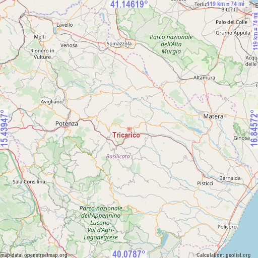
Tricarico GPS coordinates[2]
40° 36' 52.488" North, 16° 8' 33.324" East
| Map corner | latitude | longitude |
|---|---|---|
| Upper-left | 41.14619°, | 15.43947° |
| Center: | 40.61458°, | 16.14259° |
| Lower-right: | 40.0787°, | 16.84572° |
| Map W x H: | 118.7×118.7 km | = 73.8×73.8mi |
| max Lat: | 47.04031° ⇑83.4% North |
| Tricarico: | 40.61458° |
| min Lat: | ⇓16.6% South 35.50142° |
| min Long | Tricarico | max Long |
| 6.69888° | 16.14259° | 18.48682° |
| W 93.9%⇐ | ⇒6.1% E |
Elevation
Elevation of Tricarico is 711 m = 2333 ft, and this is 404.3 m = 1326 ft above average elevation for this country.
| Max E: |
2085 m = 6841 ft | 10.4% |
| Tricarico | 711 m 2333 ft | |
| Avg. | 306.7 m = 1006 ft | |
Min E: |
-4 m = -13 ft | 89.6% |
See also: Italy elevation on elevation.city.
Geographical zone
Tricarico is located in North temperate zone (between Tropic of Cancer and the Arctic Circle). Distance of this Northern Tropic circle is 1910 km =1186.8 mi to South.| Distance of | km | miles | from Tricarico |
|---|---|---|---|
| North Pole | 5491.1 | 3412 | to North |
| Arctic Circle | 2885.3 | 1792.8 | to North |
| Tropic Cancer | 1910 | 1186.8 | to South |
| Equator | 4515.9 | 2806 | to South |


Nearby cities:
15 places around Tricarico: (largest is in red/bold)
• Accettura
13.8 km =8.6 mi,  174°
174°
• Albano di Lucania
9.4 km =5.8 mi,  250°
250°
• Brindisi Montagna
17.1 km =10.6 mi,  268°
268°
• Calciano
5.1 km =3.2 mi,  125°
125°
• Campomaggiore
8 km =5 mi,  227°
227°
• Castelmezzano
12.6 km =7.8 mi,  220°
220°
• Garaguso
10.3 km =6.4 mi,  135°
135°
• Grassano
11.6 km =7.2 mi,  78°
78°
• Irsina
17.1 km =10.6 mi,  28°
28°
• Oliveto Lucano
9.5 km =5.9 mi,  157°
157°
• Pietrapertosa
12.8 km =8 mi,  212°
212°
• San Chirico Nuovo
8.8 km =5.5 mi,  322°
322°
• San Mauro Forte
17.3 km =10.7 mi,  147°
147°
• Tolve
13.9 km =8.6 mi,  309°
309°
• Trivigno
13.6 km =8.5 mi, 253°
Sources, notices
• [Note1] Compared only with cities in Italy existing in our database
• [Src1] Map data: © OpenStreetMap contributors (CC-BY-SA)
• [Src2] Other city data from geonames.org with taken over terms of usage.
• [Src3] Geographical zone / Annual Mean Temperature by Robert A. Rohde @ Wikipedia
