Terontola geodata
Terontola (Tuscany) is a populated place; located in Italy in Europe/Rome (GMT+2) time zone. With population of 1,608 people, there are 4885 cities with bigger population in this country. Compared to other cities in Italy, 61.7% of cities are located further ↑North; 56% of cities are located further ←West and 56.4% of cities have lower elevation than Terontola. Note1


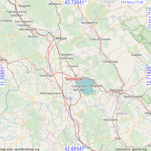
Terontola GPS coordinates[2]
43° 12' 36.324" North, 12° 0' 40.068" East
| Map corner | latitude | longitude |
|---|---|---|
| Upper-left | 43.72041°, | 11.30801° |
| Center: | 43.21009°, | 12.01113° |
| Lower-right: | 42.69547°, | 12.71426° |
| Map W x H: | 114×114 km | = 70.8×70.8mi |
| max Lat: | 47.04031° ⇑61.7% North |
| Terontola: | 43.21009° |
| min Lat: | ⇓38.3% South 35.50142° |
| min Long | Terontola | max Long |
| 6.69888° | 12.01113° | 18.48682° |
| W 56%⇐ | ⇒44% E |
Elevation
Elevation of Terontola is 274 m = 899 ft, and this is 32.7 m = 107 ft below average elevation for this country.
| Max E: |
2085 m = 6841 ft | 43.6% |
| Avg. | 306.7 m = 1006 ft | |
| Terontola | 274 m = 899 ft | |
Min E: |
-4 m = -13 ft | 56.4% |
See also: Italy elevation on elevation.city.
Geographical zone
Terontola is located in North temperate zone (between Tropic of Cancer and the Arctic Circle). Distance of this Northern Tropic circle is 2198.6 km =1366.1 mi to South.| Distance of | km | miles | from Terontola |
|---|---|---|---|
| North Pole | 5202.6 | 3232.7 | to North |
| Arctic Circle | 2596.7 | 1613.5 | to North |
| Tropic Cancer | 2198.6 | 1366.1 | to South |
| Equator | 4804.5 | 2985.4 | to South |


Nearby cities:
15 places around Terontola: (largest is in red/bold)
• Acquaviva
16 km =9.9 mi,  228°
228°
• Camucia-Monsigliolo
6.4 km =4 mi,  329°
329°
• Castiglione del Lago
9.8 km =6.1 mi,  166°
166°
• Cortona
7.5 km =4.7 mi,  343°
343°
• Fratta-Santa Caterina
10.1 km =6.3 mi,  316°
316°
• Lisciano Niccone
11.4 km =7.1 mi,  69°
69°
• Montecchio
7.1 km =4.4 mi,  291°
291°
• Montecchio
13.4 km =8.3 mi, 328°
• Montepulciano Stazione
15.1 km =9.4 mi,  236°
236°
• Passignano sul Trasimeno
10.3 km =6.4 mi,  102°
102°
• Pozzuolo
10.8 km =6.7 mi,  204°
204°
• Pucciarelli
13.7 km =8.5 mi, 165°
• San Fatucchio
15.2 km =9.4 mi, 167°
• Tre Berte
15.9 km =9.9 mi,  218°
218°
• Tuoro sul Trasimeno
5.2 km =3.2 mi,  94°
94°
Sources, notices
• [Note1] Compared only with cities in Italy existing in our database
• [Src1] Map data: © OpenStreetMap contributors (CC-BY-SA)
• [Src2] Other city data from geonames.org with taken over terms of usage.
• [Src3] Geographical zone / Annual Mean Temperature by Robert A. Rohde @ Wikipedia
