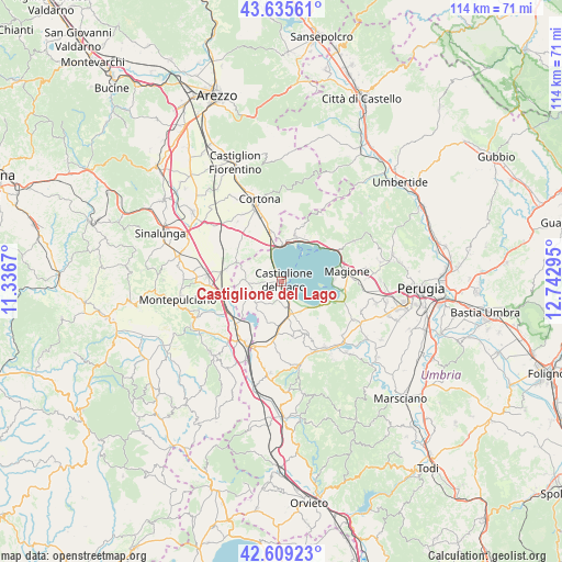
Castiglione del Lago geodata
Castiglione del Lago (Umbria) is a seat of a third-order administrative division; located in Italy in Europe/Rome (GMT+2) time zone. With population of 5,344 people, there are 1829 cities with bigger population in this country. Compared to other cities in Italy, 62.4% of cities are located further ↑North; 56.4% of cities are located further ←West and 54.7% of cities have lower elevation than Castiglione del Lago. Note1
Administrative division(s):
- Level 1: Umbria
- Level 2: Provincia di Perugia
- Level 3: Castiglione del Lago
Current local time in Castiglione del Lago:
07:41 AM, WednesdayDifference from your time zone: hours


Castiglione del Lago GPS coordinates[2]
43° 7' 28.452" North, 12° 2' 23.352" East
| Map corner | latitude | longitude |
|---|---|---|
| Upper-left | 43.63561°, | 11.3367° |
| Center: | 43.12457°, | 12.03982° |
| Lower-right: | 42.60923°, | 12.74295° |
| Map W x H: | 114.1×114.1 km | = 70.9×70.9mi |
| max Lat: | 47.04031° ⇑62.4% North |
| Castiglione del Lago: | 43.12457° |
| min Lat: | ⇓37.6% South 35.50142° |
| min Long | Castiglione del | max Long |
| 6.69888° | 12.03982° | 18.48682° |
| W 56.4%⇐ | ⇒43.6% E |
Elevation
Elevation of Castiglione del Lago is 264 m = 866 ft, and this is 42.7 m = 140 ft below average elevation for this country.
| Max E: |
2085 m = 6841 ft | 45.3% |
| Avg. | 306.7 m = 1006 ft | |
| Castiglione del Lago | 264 m = 866 ft | |
Min E: |
-4 m = -13 ft | 54.7% |
See also: Italy elevation on elevation.city.
Geographical zone
Castiglione del Lago is located in North temperate zone (between Tropic of Cancer and the Arctic Circle). Distance of this Northern Tropic circle is 2189.1 km =1360.2 mi to South.| Distance of | km | miles | from Castiglione del Lago |
|---|---|---|---|
| North Pole | 5212.1 | 3238.6 | to North |
| Arctic Circle | 2606.2 | 1619.4 | to North |
| Tropic Cancer | 2189.1 | 1360.2 | to South |
| Equator | 4795 | 2979.5 | to South |


Nearby cities:
15 places around Castiglione del Lago: (largest is in red/bold)
• Macchie
7.6 km =4.7 mi,  159°
159°
• Moiano
12.4 km =7.7 mi,  188°
188°
• Paciano
11.5 km =7.1 mi,  168°
168°
• Panicale
11.8 km =7.3 mi, 155°
• Panicarola
7.2 km =4.5 mi,  148°
148°
• Passignano sul Trasimeno
10.7 km =6.6 mi,  46°
46°
• Pozzuolo
6.8 km =4.2 mi,  267°
267°
• Pucciarelli
3.9 km =2.4 mi, 163°
• San Fatucchio
5.4 km =3.4 mi, 169°
• San Feliciano
10.3 km =6.4 mi,  94°
94°
• San Savino
12.6 km =7.8 mi,  98°
98°
• Sant'Arcangelo
10.7 km =6.6 mi,  114°
114°
• Terontola
9.8 km =6.1 mi,  346°
346°
• Tre Berte
12.5 km =7.8 mi,  256°
256°
• Tuoro sul Trasimeno
9.5 km =5.9 mi,  17°
17°
Sources, notices
• [Note1] Compared only with cities in Italy existing in our database
• [Src1] Map data: © OpenStreetMap contributors (CC-BY-SA)
• [Src2] Other city data from geonames.org with taken over terms of usage.
• [Src3] Geographical zone / Annual Mean Temperature by Robert A. Rohde @ Wikipedia
