Taranto geodata
Taranto (Apulia) is a seat of a second-order administrative division; located in Italy in Europe/Rome (GMT+2) time zone. With population of 181,082 people, there are 16 cities with bigger population in this country. Compared to other cities in Italy, 84.3% of cities are located further ↑North; 98.3% of cities are located further ←West and 92.6% of cities have higher elevation than Taranto. Note1


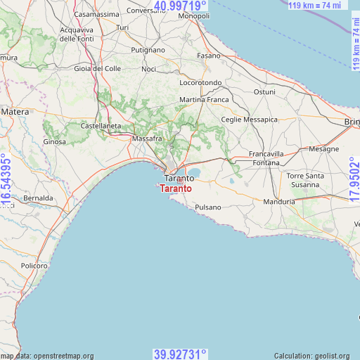
Taranto GPS coordinates[2]
40° 27' 51.768" North, 17° 14' 49.452" East
| Map corner | latitude | longitude |
|---|---|---|
| Upper-left | 40.99719°, | 16.54395° |
| Center: | 40.46438°, | 17.24707° |
| Lower-right: | 39.92731°, | 17.9502° |
| Map W x H: | 119×119 km | = 73.9×73.9mi |
| max Lat: | 47.04031° ⇑84.3% North |
| Taranto: | 40.46438° |
| min Lat: | ⇓15.7% South 35.50142° |
| min Long | Taranto | max Long |
| 6.69888° | 17.24707° | 18.48682° |
| W 98.3%⇐ | ⇒1.7% E |
Elevation
Elevation of Taranto is 13 m = 43 ft, and this is 293.7 m = 964 ft below average elevation for this country.
| Max E: |
2085 m = 6841 ft | 92.6% |
| Avg. | 306.7 m = 1006 ft | |
| Taranto | 13 m = 43 ft | |
Min E: |
-4 m = -13 ft | 7.4% |
See also: Taranto elevation on elevation.city.
Geographical zone
Taranto is located in North temperate zone (between Tropic of Cancer and the Arctic Circle). Distance of this Northern Tropic circle is 1893.3 km =1176.4 mi to South.| Distance of | km | miles | from Taranto |
|---|---|---|---|
| North Pole | 5507.8 | 3422.4 | to North |
| Arctic Circle | 2902 | 1803.2 | to North |
| Tropic Cancer | 1893.3 | 1176.4 | to South |
| Equator | 4499.2 | 2795.7 | to South |


Nearby cities:
15 places around Taranto: (largest is in red/bold)
• Carosino
12.8 km =8 mi,  89°
89°
• Crispiano
15.5 km =9.6 mi,  355°
355°
• Faggiano
13.1 km =8.1 mi,  114°
114°
• Leporano
11.7 km =7.3 mi,  141°
141°
• Leporano Marina
10.9 km =6.8 mi,  150°
150°
• Lido Azzurro
10.9 km =6.8 mi,  302°
302°
• Monteiasi
12.1 km =7.5 mi,  70°
70°
• Montemesola
13.7 km =8.5 mi,  33°
33°
• Monteparano
14.2 km =8.8 mi,  99°
99°
• Paolo VI
6.8 km =4.2 mi,  19°
19°
• Parco di Guerra
15 km =9.3 mi,  326°
326°
• Pulsano
13.1 km =8.1 mi, 135°
• Roccaforzata
12.5 km =7.8 mi, 104°
• San Giorgio Ionico
11.3 km =7 mi, 93°
• Statte
8.1 km =5 mi, 331°
Sources, notices
• [Note1] Compared only with cities in Italy existing in our database
• [Src1] Map data: © OpenStreetMap contributors (CC-BY-SA)
• [Src2] Other city data from geonames.org with taken over terms of usage.
• [Src3] Geographical zone / Annual Mean Temperature by Robert A. Rohde @ Wikipedia
