Pulsano geodata
Pulsano (Apulia) is a seat of a third-order administrative division; located in Italy in Europe/Rome (GMT+2) time zone. With population of 9,197 people, there are 1033 cities with bigger population in this country. Compared to other cities in Italy, 85% of cities are located further ↑North; 98.4% of cities are located further ←West and 82% of cities have higher elevation than Pulsano. Note1


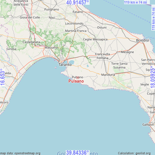
Pulsano GPS coordinates[2]
40° 22' 51.924" North, 17° 21' 22.032" East
| Map corner | latitude | longitude |
|---|---|---|
| Upper-left | 40.91457°, | 16.653° |
| Center: | 40.38109°, | 17.35612° |
| Lower-right: | 39.84336°, | 18.05925° |
| Map W x H: | 119.1×119.1 km | = 74×74mi |
| max Lat: | 47.04031° ⇑85% North |
| Pulsano: | 40.38109° |
| min Lat: | ⇓15% South 35.50142° |
| min Long | Pulsano | max Long |
| 6.69888° | 17.35612° | 18.48682° |
| W 98.4%⇐ | ⇒1.6% E |
Elevation
Elevation of Pulsano is 42 m = 138 ft, and this is 264.7 m = 868 ft below average elevation for this country.
| Max E: |
2085 m = 6841 ft | 82% |
| Avg. | 306.7 m = 1006 ft | |
| Pulsano | 42 m = 138 ft | |
Min E: |
-4 m = -13 ft | 18% |
See also: Italy elevation on elevation.city.
Geographical zone
Pulsano is located in North temperate zone (between Tropic of Cancer and the Arctic Circle). Distance of this Northern Tropic circle is 1884 km =1170.7 mi to South.| Distance of | km | miles | from Pulsano |
|---|---|---|---|
| North Pole | 5517.1 | 3428.2 | to North |
| Arctic Circle | 2911.2 | 1808.9 | to North |
| Tropic Cancer | 1884 | 1170.7 | to South |
| Equator | 4490 | 2790 | to South |


Nearby cities:
15 places around Pulsano: (largest is in red/bold)
• Carosino
10 km =6.2 mi,  20°
20°
• Faggiano
4.8 km =3 mi,  35°
35°
• Fragagnano
11.5 km =7.1 mi,  61°
61°
• Leporano
1.9 km =1.2 mi,  273°
273°
• Leporano Marina
3.9 km =2.4 mi, 265°
• Lizzano
7.7 km =4.8 mi,  80°
80°
• Monteiasi
13.4 km =8.3 mi,  9°
9°
• Monteparano
8.4 km =5.2 mi,  34°
34°
• Monti d'Arena-Bosco Caggione
3 km =1.9 mi,  166°
166°
• Roccaforzata
6.8 km =4.2 mi, 24°
• San Giorgio Ionico
8.8 km =5.5 mi, 13°
• San Marzano di San Giuseppe
14.9 km =9.3 mi, 56°
• Sava
16.8 km =10.4 mi, 82°
• Taranto
13.1 km =8.1 mi,  315°
315°
• Torricella
12.4 km =7.7 mi,  103°
103°
Sources, notices
• [Note1] Compared only with cities in Italy existing in our database
• [Src1] Map data: © OpenStreetMap contributors (CC-BY-SA)
• [Src2] Other city data from geonames.org with taken over terms of usage.
• [Src3] Geographical zone / Annual Mean Temperature by Robert A. Rohde @ Wikipedia
