Strigno geodata
Strigno (Trentino-Alto Adige) is a seat of a third-order administrative division; located in Italy in Europe/Rome (GMT+2) time zone. With population of 1,377 people, there are 5415 cities with bigger population in this country. Compared to other cities in Italy, 93.4% of cities are located further ↓South; 50.3% of cities are located further →East and 76.5% of cities have lower elevation than Strigno. Note1
Administrative division(s):
- Level 1: Trentino-Alto Adige
- Level 2: Provincia autonoma di Trento
- Level 3: Castel Ivano


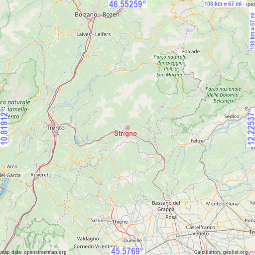
Strigno GPS coordinates[2]
46° 4' 0.84" North, 11° 31' 20.064" East
| Map corner | latitude | longitude |
|---|---|---|
| Upper-left | 46.55259°, | 10.81912° |
| Center: | 46.0669°, | 11.52224° |
| Lower-right: | 45.5769°, | 12.22537° |
| Map W x H: | 108.5×108.5 km | = 67.4×67.4mi |
| max Lat: | 47.04031° ⇑6.6% North |
| Strigno: | 46.0669° |
| min Lat: | ⇓93.4% South 35.50142° |
| min Long | Strigno | max Long |
| 6.69888° | 11.52224° | 18.48682° |
| W 49.7%⇐ | ⇒50.3% E |
Elevation
Elevation of Strigno is 473 m = 1552 ft, and this is 166.3 m = 546 ft above average elevation for this country.
| Max E: |
2085 m = 6841 ft | 23.5% |
| Strigno | 473 m 1552 ft | |
| Avg. | 306.7 m = 1006 ft | |
Min E: |
-4 m = -13 ft | 76.5% |
See also: Italy elevation on elevation.city.
Geographical zone
Strigno is located in North temperate zone (between Tropic of Cancer and the Arctic Circle). Distance of this North polar circle is 2279 km =1416.1 mi to North.| Distance of | km | miles | from Strigno |
|---|---|---|---|
| North Pole | 4884.9 | 3035.3 | to North |
| Arctic Circle | 2279 | 1416.1 | to North |
| Tropic Cancer | 2516.2 | 1563.5 | to South |
| Equator | 5122.2 | 3182.8 | to South |


Nearby cities:
15 places around Strigno: (largest is in red/bold)
• Bieno
3.1 km =1.9 mi,  58°
58°
• Borgo Valsugana
5.3 km =3.3 mi,  250°
250°
• Carzano
2.2 km =1.4 mi,  281°
281°
• Castelnuovo
2.9 km =1.8 mi,  240°
240°
• Olle
5.2 km =3.2 mi, 236°
• Ospedaletto
3.6 km =2.2 mi,  137°
137°
• Pieve Tesino
6.9 km =4.3 mi,  88°
88°
• Ronchi Valsugana
6.7 km =4.2 mi,  271°
271°
• Samone
1.6 km =1 mi,  0°
0°
• Scurelle
1.3 km =0.8 mi,  258°
258°
• Spera
1.1 km =0.7 mi,  290°
290°
• Telve
3.3 km =2.1 mi, 276°
• Telve di Sopra
3.9 km =2.4 mi, 277°
• Torcegno
5.6 km =3.5 mi, 278°
• Villa-Agnedo
1.5 km =0.9 mi,  161°
161°
Sources, notices
• [Note1] Compared only with cities in Italy existing in our database
• [Src1] Map data: © OpenStreetMap contributors (CC-BY-SA)
• [Src2] Other city data from geonames.org with taken over terms of usage.
• [Src3] Geographical zone / Annual Mean Temperature by Robert A. Rohde @ Wikipedia
