Spera geodata
Spera (Trentino-Alto Adige) is a seat of a third-order administrative division; located in Italy in Europe/Rome (GMT+2) time zone. With population of 476 people, there are 10002 cities with bigger population in this country. Compared to other cities in Italy, 93.5% of cities are located further ↓South; 50.5% of cities are located further →East and 81.9% of cities have lower elevation than Spera. Note1
Administrative division(s):
- Level 1: Trentino-Alto Adige
- Level 2: Provincia autonoma di Trento
- Level 3: Castel Ivano


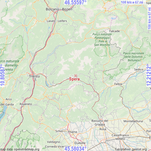
Spera GPS coordinates[2]
46° 4' 13.116" North, 11° 30' 32.364" East
| Map corner | latitude | longitude |
|---|---|---|
| Upper-left | 46.55597°, | 10.80587° |
| Center: | 46.07031°, | 11.50899° |
| Lower-right: | 45.58034°, | 12.21212° |
| Map W x H: | 108.5×108.5 km | = 67.4×67.4mi |
| max Lat: | 47.04031° ⇑6.5% North |
| Spera: | 46.07031° |
| min Lat: | ⇓93.5% South 35.50142° |
| min Long | Spera | max Long |
| 6.69888° | 11.50899° | 18.48682° |
| W 49.5%⇐ | ⇒50.5% E |
Elevation
Elevation of Spera is 553 m = 1814 ft, and this is 246.3 m = 808 ft above average elevation for this country.
| Max E: |
2085 m = 6841 ft | 18.1% |
| Spera | 553 m 1814 ft | |
| Avg. | 306.7 m = 1006 ft | |
Min E: |
-4 m = -13 ft | 81.9% |
See also: Italy elevation on elevation.city.
Geographical zone
Spera is located in North temperate zone (between Tropic of Cancer and the Arctic Circle). Distance of this North polar circle is 2278.6 km =1415.9 mi to North.| Distance of | km | miles | from Spera |
|---|---|---|---|
| North Pole | 4884.5 | 3035.1 | to North |
| Arctic Circle | 2278.6 | 1415.9 | to North |
| Tropic Cancer | 2516.6 | 1563.7 | to South |
| Equator | 5122.5 | 3183 | to South |


Nearby cities:
15 places around Spera: (largest is in red/bold)
• Bieno
3.8 km =2.4 mi,  71°
71°
• Borgo Valsugana
4.5 km =2.8 mi,  241°
241°
• Carzano
1.2 km =0.7 mi,  273°
273°
• Castelnuovo
2.4 km =1.5 mi,  220°
220°
• Olle
4.7 km =2.9 mi,  225°
225°
• Ospedaletto
4.6 km =2.9 mi,  131°
131°
• Pieve Tesino
7.9 km =4.9 mi,  91°
91°
• Ronchi Valsugana
5.7 km =3.5 mi, 267°
• Samone
1.6 km =1 mi,  39°
39°
• Scurelle
0.7 km =0.4 mi,  201°
201°
• Strigno
1.1 km =0.7 mi,  110°
110°
• Telve
2.2 km =1.4 mi, 269°
• Telve di Sopra
2.9 km =1.8 mi, 272°
• Torcegno
4.6 km =2.9 mi,  275°
275°
• Villa-Agnedo
2.3 km =1.4 mi,  140°
140°
Sources, notices
• [Note1] Compared only with cities in Italy existing in our database
• [Src1] Map data: © OpenStreetMap contributors (CC-BY-SA)
• [Src2] Other city data from geonames.org with taken over terms of usage.
• [Src3] Geographical zone / Annual Mean Temperature by Robert A. Rohde @ Wikipedia
