Sternatia geodata
Sternatia (Apulia) is a seat of a third-order administrative division; located in Italy in Europe/Rome (GMT+2) time zone. With population of 2,308 people, there are 3748 cities with bigger population in this country. Compared to other cities in Italy, 86.3% of cities are located further ↑North; 99.4% of cities are located further ←West and 73.8% of cities have higher elevation than Sternatia. Note1


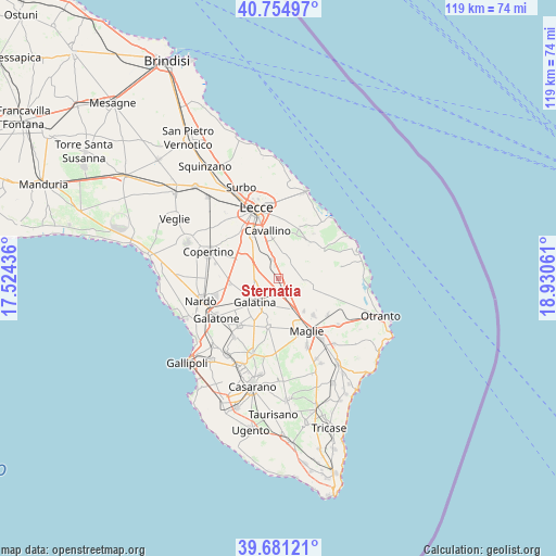
Sternatia GPS coordinates[2]
40° 13' 12.792" North, 18° 13' 38.928" East
| Map corner | latitude | longitude |
|---|---|---|
| Upper-left | 40.75497°, | 17.52436° |
| Center: | 40.22022°, | 18.22748° |
| Lower-right: | 39.68121°, | 18.93061° |
| Map W x H: | 119.4×119.4 km | = 74.2×74.2mi |
| max Lat: | 47.04031° ⇑86.3% North |
| Sternatia: | 40.22022° |
| min Lat: | ⇓13.7% South 35.50142° |
| min Long | Sternatia | max Long |
| 6.69888° | 18.22748° | 18.48682° |
| W 99.4%⇐ | ⇒0.59999999999999% E |
Elevation
Elevation of Sternatia is 79 m = 259 ft, and this is 227.7 m = 747 ft below average elevation for this country.
| Max E: |
2085 m = 6841 ft | 73.8% |
| Avg. | 306.7 m = 1006 ft | |
| Sternatia | 79 m = 259 ft | |
Min E: |
-4 m = -13 ft | 26.2% |
See also: Italy elevation on elevation.city.
Geographical zone
Sternatia is located in North temperate zone (between Tropic of Cancer and the Arctic Circle). Distance of this Northern Tropic circle is 1866.2 km =1159.6 mi to South.| Distance of | km | miles | from Sternatia |
|---|---|---|---|
| North Pole | 5535 | 3439.3 | to North |
| Arctic Circle | 2929.1 | 1820.1 | to North |
| Tropic Cancer | 1866.2 | 1159.6 | to South |
| Equator | 4472.1 | 2778.8 | to South |


Nearby cities:
15 places around Sternatia: (largest is in red/bold)
• Calimera
5.5 km =3.4 mi,  53°
53°
• Caprarica di Lecce
4.7 km =2.9 mi,  17°
17°
• Castri di Lecce
6.6 km =4.1 mi,  26°
26°
• Castrignano De' Greci
7.8 km =4.8 mi,  131°
131°
• Corigliano d'Otranto
7.2 km =4.5 mi,  160°
160°
• Galatina
7.1 km =4.4 mi,  223°
223°
• Galugnano
4.1 km =2.5 mi,  344°
344°
• Martano
6.6 km =4.1 mi,  107°
107°
• Martignano
3.1 km =1.9 mi, 50°
• Melpignano
9 km =5.6 mi,  142°
142°
• Noha
9.1 km =5.7 mi, 215°
• San Donato di Lecce
6.5 km =4 mi,  323°
323°
• Sogliano Cavour
8.4 km =5.2 mi,  197°
197°
• Soleto
4 km =2.5 mi,  206°
206°
• Zollino
2.4 km =1.5 mi, 132°
Sources, notices
• [Note1] Compared only with cities in Italy existing in our database
• [Src1] Map data: © OpenStreetMap contributors (CC-BY-SA)
• [Src2] Other city data from geonames.org with taken over terms of usage.
• [Src3] Geographical zone / Annual Mean Temperature by Robert A. Rohde @ Wikipedia
