Martignano geodata
Martignano (Apulia) is a seat of a third-order administrative division; located in Italy in Europe/Rome (GMT+2) time zone. With population of 1,697 people, there are 4673 cities with bigger population in this country. Compared to other cities in Italy, 86.2% of cities are located further ↑North; 99.5% of cities are located further ←West and 71.3% of cities have higher elevation than Martignano. Note1


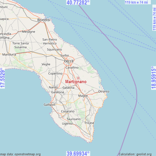
Martignano GPS coordinates[2]
40° 14' 17.556" North, 18° 15' 21.672" East
| Map corner | latitude | longitude |
|---|---|---|
| Upper-left | 40.77282°, | 17.5529° |
| Center: | 40.23821°, | 18.25602° |
| Lower-right: | 39.69934°, | 18.95915° |
| Map W x H: | 119.4×119.4 km | = 74.2×74.2mi |
| max Lat: | 47.04031° ⇑86.2% North |
| Martignano: | 40.23821° |
| min Lat: | ⇓13.8% South 35.50142° |
| min Long | Martignano | max Long |
| 6.69888° | 18.25602° | 18.48682° |
| W 99.5%⇐ | ⇒0.5% E |
Elevation
Elevation of Martignano is 91 m = 299 ft, and this is 215.7 m = 708 ft below average elevation for this country.
| Max E: |
2085 m = 6841 ft | 71.3% |
| Avg. | 306.7 m = 1006 ft | |
| Martignano | 91 m = 299 ft | |
Min E: |
-4 m = -13 ft | 28.7% |
See also: Italy elevation on elevation.city.
Geographical zone
Martignano is located in North temperate zone (between Tropic of Cancer and the Arctic Circle). Distance of this Northern Tropic circle is 1868.2 km =1160.8 mi to South.| Distance of | km | miles | from Martignano |
|---|---|---|---|
| North Pole | 5533 | 3438 | to North |
| Arctic Circle | 2927.1 | 1818.8 | to North |
| Tropic Cancer | 1868.2 | 1160.8 | to South |
| Equator | 4474.1 | 2780.1 | to South |


Nearby cities:
15 places around Martignano: (largest is in red/bold)
• Calimera
2.4 km =1.5 mi,  58°
58°
• Caprarica di Lecce
2.7 km =1.7 mi,  338°
338°
• Carpignano Salentino
8.5 km =5.3 mi,  124°
124°
• Castri di Lecce
4 km =2.5 mi,  7°
7°
• Castrignano De' Greci
8 km =5 mi,  154°
154°
• Galugnano
4 km =2.5 mi,  299°
299°
• Lizzanello
7.9 km =4.9 mi, 339°
• Martano
5.6 km =3.5 mi,  135°
135°
• Melendugno
7.9 km =4.9 mi, 61°
• Pisignano
7.5 km =4.7 mi, 10°
• San Donato di Lecce
7 km =4.3 mi, 297°
• Soleto
7 km =4.3 mi,  216°
216°
• Sternatia
3.1 km =1.9 mi,  230°
230°
• Vernole
6.8 km =4.2 mi,  34°
34°
• Zollino
3.7 km =2.3 mi,  191°
191°
Sources, notices
• [Note1] Compared only with cities in Italy existing in our database
• [Src1] Map data: © OpenStreetMap contributors (CC-BY-SA)
• [Src2] Other city data from geonames.org with taken over terms of usage.
• [Src3] Geographical zone / Annual Mean Temperature by Robert A. Rohde @ Wikipedia
