Stazzano geodata
Stazzano (Piedmont) is a seat of a third-order administrative division; located in Italy in Europe/Rome (GMT+2) time zone. With population of 2,021 people, there are 4121 cities with bigger population in this country. Compared to other cities in Italy, 54.8% of cities are located further ↓South; 83.3% of cities are located further →East and 52.2% of cities have higher elevation than Stazzano. Note1


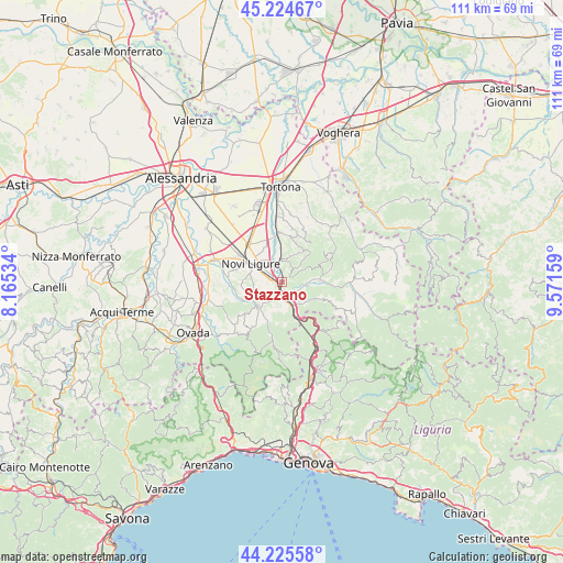
Stazzano GPS coordinates[2]
44° 43' 38.208" North, 8° 52' 6.456" East
| Map corner | latitude | longitude |
|---|---|---|
| Upper-left | 45.22467°, | 8.16534° |
| Center: | 44.72728°, | 8.86846° |
| Lower-right: | 44.22558°, | 9.57159° |
| Map W x H: | 111.1×111.1 km | = 69×69mi |
| max Lat: | 47.04031° ⇑45.2% North |
| Stazzano: | 44.72728° |
| min Lat: | ⇓54.8% South 35.50142° |
| min Long | Stazzano | max Long |
| 6.69888° | 8.86846° | 18.48682° |
| W 16.7%⇐ | ⇒83.3% E |
Elevation
Elevation of Stazzano is 221 m = 725 ft, and this is 85.7 m = 281 ft below average elevation for this country.
| Max E: |
2085 m = 6841 ft | 52.2% |
| Avg. | 306.7 m = 1006 ft | |
| Stazzano | 221 m = 725 ft | |
Min E: |
-4 m = -13 ft | 47.8% |
See also: Italy elevation on elevation.city.
Geographical zone
Stazzano is located in North temperate zone (between Tropic of Cancer and the Arctic Circle). Distance of this Northern Tropic circle is 2367.3 km =1471 mi to South.| Distance of | km | miles | from Stazzano |
|---|---|---|---|
| North Pole | 5033.9 | 3127.9 | to North |
| Arctic Circle | 2428 | 1508.7 | to North |
| Tropic Cancer | 2367.3 | 1471 | to South |
| Equator | 4973.2 | 3090.2 | to South |


Nearby cities:
15 places around Stazzano: (largest is in red/bold)
• Arquata Scrivia
4.6 km =2.9 mi,  161°
161°
• Borghetto di Borbera
5.9 km =3.7 mi,  87°
87°
• Carezzano Maggiore
9.2 km =5.7 mi,  15°
15°
• Carrosio
8.3 km =5.2 mi,  200°
200°
• Cassano Spinola
4.3 km =2.7 mi,  353°
353°
• Gavazzana
5.6 km =3.5 mi,  14°
14°
• Gavi
6.7 km =4.2 mi,  226°
226°
• Grondona
8.4 km =5.2 mi,  114°
114°
• Novi Ligure
7.5 km =4.7 mi,  301°
301°
• Sant'Agata Fossili
7.6 km =4.7 mi,  33°
33°
• Sardigliano
3.5 km =2.2 mi,  37°
37°
• Serravalle Scrivia
1.1 km =0.7 mi,  242°
242°
• Tassarolo
7.6 km =4.7 mi,  270°
270°
• Torreratti-Persi
7.8 km =4.8 mi, 85°
• Vignole Borbera
2.7 km =1.7 mi,  140°
140°
Sources, notices
• [Note1] Compared only with cities in Italy existing in our database
• [Src1] Map data: © OpenStreetMap contributors (CC-BY-SA)
• [Src2] Other city data from geonames.org with taken over terms of usage.
• [Src3] Geographical zone / Annual Mean Temperature by Robert A. Rohde @ Wikipedia
