Torreratti-Persi geodata
Torreratti-Persi (Piedmont) is a populated place; located in Italy in Europe/Rome (GMT+2) time zone. With population of 601 people, there are 8996 cities with bigger population in this country. Compared to other cities in Italy, 54.9% of cities are located further ↓South; 81.7% of cities are located further →East and 62.8% of cities have lower elevation than Torreratti-Persi. Note1
Administrative division(s):
- Level 1: Piedmont
- Level 2: Provincia di Alessandria
- Level 3: Borghetto di Borbera


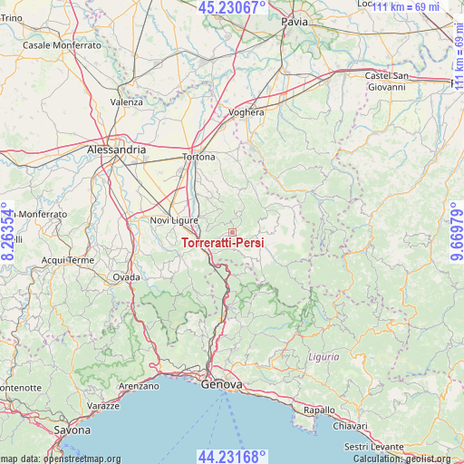
Torreratti-Persi GPS coordinates[2]
44° 43' 59.988" North, 8° 58' 0.012" East
| Map corner | latitude | longitude |
|---|---|---|
| Upper-left | 45.23067°, | 8.26354° |
| Center: | 44.73333°, | 8.96667° |
| Lower-right: | 44.23168°, | 9.66979° |
| Map W x H: | 111.1×111.1 km | = 69×69mi |
| max Lat: | 47.04031° ⇑45.1% North |
| Torreratti-Persi: | 44.73333° |
| min Lat: | ⇓54.9% South 35.50142° |
| min Long | Torreratti-Pers | max Long |
| 6.69888° | 8.96667° | 18.48682° |
| W 18.3%⇐ | ⇒81.7% E |
Elevation
Elevation of Torreratti-Persi is 321 m = 1053 ft, and this is 14.3 m = 47 ft above average elevation for this country.
| Max E: |
2085 m = 6841 ft | 37.2% |
| Torreratti-Persi | 321 m 1053 ft | |
| Avg. | 306.7 m = 1006 ft | |
Min E: |
-4 m = -13 ft | 62.8% |
See also: Italy elevation on elevation.city.
Geographical zone
Torreratti-Persi is located in North temperate zone (between Tropic of Cancer and the Arctic Circle). Distance of this Northern Tropic circle is 2368 km =1471.4 mi to South.| Distance of | km | miles | from Torreratti-Persi |
|---|---|---|---|
| North Pole | 5033.2 | 3127.5 | to North |
| Arctic Circle | 2427.3 | 1508.3 | to North |
| Tropic Cancer | 2368 | 1471.4 | to South |
| Equator | 4973.9 | 3090.6 | to South |


Nearby cities:
15 places around Torreratti-Persi: (largest is in red/bold)
• Arquata Scrivia
8.1 km =5 mi,  231°
231°
• Avolasca
7.8 km =4.8 mi,  359°
359°
• Borghetto di Borbera
1.9 km =1.2 mi,  256°
256°
• Cantalupo Ligure
6.5 km =4 mi,  105°
105°
• Castellania
7.8 km =4.8 mi,  338°
338°
• Dernice
7.5 km =4.7 mi,  60°
60°
• Garbagna
5.8 km =3.6 mi,  25°
25°
• Gavazzana
7.9 km =4.9 mi,  306°
306°
• Grondona
4.1 km =2.5 mi,  181°
181°
• Roccaforte Ligure
7.8 km =4.8 mi,  141°
141°
• Rocchetta Ligure
7.3 km =4.5 mi, 114°
• Sant'Agata Fossili
6.8 km =4.2 mi,  327°
327°
• Sardigliano
6 km =3.7 mi,  290°
290°
• Stazzano
7.8 km =4.8 mi,  265°
265°
• Vignole Borbera
6.7 km =4.2 mi,  245°
245°
Sources, notices
• [Note1] Compared only with cities in Italy existing in our database
• [Src1] Map data: © OpenStreetMap contributors (CC-BY-SA)
• [Src2] Other city data from geonames.org with taken over terms of usage.
• [Src3] Geographical zone / Annual Mean Temperature by Robert A. Rohde @ Wikipedia
